The Enduring Sentinel: Mohonk's Sky Top Tower and Its View from New Paltz
“There is always that North Star guiding us, marking our progress towards home. For the past century, that particular star has been the light inside the Albert K. Smiley Memorial Tower.”
📅 New Paltz, NY·🏔️ HV History·⏱ 8 min read
Sky Top Tower · Shawangunk Ridge · New Paltz, NY · Est. 1923
Perched on the Shawangunk Ridge above New Paltz, Mohonk's Sky Top Tower is more than a stone structure on a mountain. For generations of local residents, it has been a fixed point in the landscape, something you look for instinctively when you return home from a long trip, the way a sailor looks for a lighthouse.
The tower is officially called the Albert K. Smiley Memorial Tower. It stands at 1,542 feet above sea level, built from Shawangunk conglomerate rock quarried directly from the mountaintop. On a clear day, the view from its 100 steps reaches across six states: New York, New Jersey, Pennsylvania, Connecticut, Massachusetts, and Vermont.
“For the residents of New Paltz, the tower is more than just a scenic overlook; it is an iconic landmark deeply embedded in the local identity, a ‘North Star’ or ‘beacon’ that signals home.”
Four Towers: A History of Perseverance
The stone tower you see today is actually the fourth observation structure to stand on what the Smiley family called “Sky Top”, a high point on the ridge originally known locally as Paltz Point. Each of the first three towers met an early end.
1870
Tower One: The Octagon
Alfred Smiley erected the first tower, an octagonal structure of hemlock and white pine, in the same year the Mohonk Mountain House opened. A severe windstorm destroyed it in February 1872, just months after completion.
1872
Tower Two: The Matched Pine
A second tower of matched pine, three stories tall. Alfred wrote to his brother that a violent storm struck during construction, “almost a hurricane”, but the tower held. It was destroyed by fire in May 1877.
1878
Tower Three: Seven Flights
Seven flights of stairs, four platforms, four floors. It stood for over three decades before being destroyed by fire on June 15, 1909.
1921–23
Tower Four: The Stone Memorial
Following the death of Albert Smiley in 1912, the family committed to building something permanent. Funded by 875 Mohonk guests and neighbors. Cornerstone laid August 8, 1921. Dedicated August 8, 1923.
Built to Last: The Stone Tower
In 1919, New York State proposed building a steel fire observation tower on the spot. The Smiley family objected and lobbied to build a stone structure instead. The design was overseen by architect Francis F. Allen of Allen and Collens. Bruce Smiley served as project manager. Stone mason John Lawrence and stone cutter Frank Lawrence shaped each block of Shawangunk conglomerate rock.
The quarrying process created a large cavity ingeniously converted into a 1.3-million-gallon reservoir, still used today. The tower served as an official forest fire lookout station until 1966.
By the Numbers
1,542 feet: elevation above sea level
60 feet tall: height of the stone tower
100 steps: exactly, to reach the observation platform
6 states: visible on a clear day: NY, NJ, PA, CT, MA, VT
875 donors: guests and neighbors who funded the memorial
1.3 million gallons: reservoir capacity carved from the quarry site
6,400 acres: size of the surrounding Mohonk Preserve
165,000: annual visitors to the Mohonk Preserve
1986: designated a National Historic Landmark
The View From New Paltz
The tower's significance for New Paltz residents goes beyond its history. Visible from Main Street on a clear day, it appears on the western horizon as a small but unmistakable silhouette. The name “Mohonk” may derive from the Lenape word maxkwung, meaning “hill of bears.” The Smiley brothers purchased the land in 1869 from local farmers who considered the steep, rocky terrain essentially worthless, paying roughly $10 an acre.
Where to See It
River to Ridge Trail: connects New Paltz to the Shawangunk Ridge through farm fields with frequent tower views
Butterville Road: open views toward the ridge, especially in early morning
Main Street, New Paltz: visible from town on clear days, framed by the ridgeline
Duck Pond Trailhead (Mohonk Preserve), the 6-mile Skytop Loop leads directly to the tower
Sky Top Trail: 1.6-mile moderate loop, 288 ft elevation gain, ~45 minutes. Exactly 100 steps to the top.
A Living Institution
The Smiley family has stewarded Mohonk for over 150 years, five generations. In 2023, the tower celebrated its 100th anniversary. The family has maintained over 112 years of daily weather and environmental data from the mountaintop, one of the most valuable long-term climate records in the northeastern United States.
When you wear a That Dawg Local New Paltz design, you're wearing a piece of that landscape. The ridge. The view. The tower on the hill that people have been looking up at since 1870.
References
“New Paltz's iconic Sky Top tower turns 100.” Hudson Valley One, Oct. 2023. hudsonvalleyone.com
“The Story of Sky Top: A Towering Achievement.” AboutTown. abouttown.us
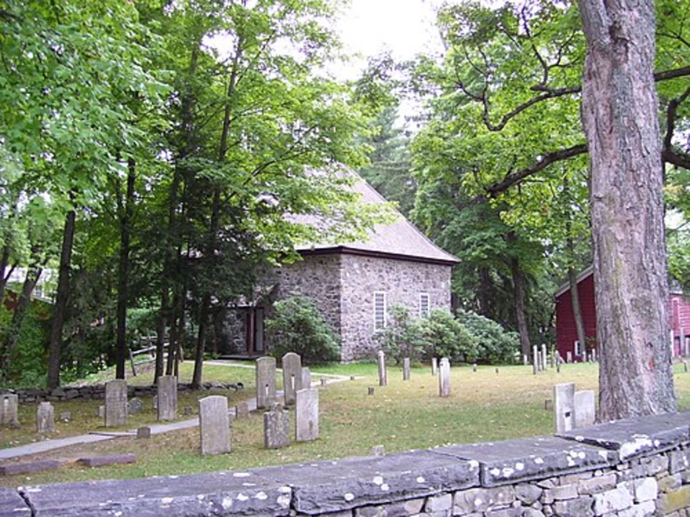
The Whispering Stones: Ghost Lore and Legends of Huguenot Street
“On Huguenot Street, the past isn't just remembered, it is felt. As the mist rises from the Wallkill to meet the ancient stone walls, the boundary between centuries grows thin.”
📅 New Paltz, NY·👻 Ghost Lore·⏱ 9 min read
Cemetery & 1717 Reformed Church · Huguenot Street · New Paltz, NY
Walk Huguenot Street after dark and something shifts. The fieldstone houses, squat, thick-walled, built to last centuries, absorb the last of the evening light and give nothing back. The Wallkill River moves quietly a short distance away. The burial ground sits still between the houses, its oldest markers worn smooth by three hundred years of Hudson Valley weather. And somewhere in the mist near the Deyo House, local legend says, a woman in white still walks.
Historic Huguenot Street is one of the oldest continuously inhabited settlements in the United States, a 10-acre, 30-building National Historic Landmark District that was the original heart of New Paltz, established in 1678 by twelve French Huguenot families who fled religious persecution in Europe. The seven stone houses that anchor the street date to the early 18th century and still stand largely intact. They are celebrated as architectural marvels. They are also, if the oral histories and reported encounters spanning more than a century are to be believed, considerably haunted.
1678
Year of Settlement
340+
Years of History
30
Buildings on 10 Acres
12
Original Patentee Families
Who Were the Huguenots?
The word “Huguenot” refers to French Protestants who faced decades of persecution in Catholic France, culminating in the revocation of the Edict of Nantes in 1685. A small group of twelve families, the Duzine, or “the twelve patentees”, eventually settled in the Wallkill River valley, purchasing land from the Esopus Munsee people and founding New Paltz.
Their names are still everywhere in this town: Hasbrouck, Deyo, Bevier, DuBois, LeFevre. They built in stone because wood rotted and burned. And they built to last, which, three centuries later, turns out to have consequences for the imagination.
“New Paltz started with 12 simple families trying to find their way in this wilderness.”, Thomas Weikel, Director of Strategy and Historic Interpretation, Historic Huguenot Street
The Spirits of the Street
The ghost stories of Huguenot Street aren't invented for tourism. They grow from a genuine oral tradition, diaries, newspaper accounts, and reported experiences passed down through generations. Historic Huguenot Street's own programming director has noted that all haunted tour stories “come straight out of the newspapers” and real archival records.
👗
The Woman in White
The most iconic spirit on the street, most often sighted near the Deyo House at twilight, a luminous figure drifting through the gardens, accompanied by a sudden chill and the feeling of being watched from the upper floors.
🕯️
The Mourning Maid
A housemaid said to haunt the Deyo House attic, perpetually grieving the tragic end of the family she served. One variation holds she is Gertrude Bogardus Deyo, a resident who lived her entire life within those walls and never fully left.
🪔
The Phantom Lanterns
Flickering lights reported moving through the Old Huguenot Burying Ground at night, resembling the oil lanterns used by early settlers, moving with apparent purpose through the oldest section of the cemetery.
🪨
The Bevier Presences
In the Bevier-Elting House, visitors and staff report flickers of light in windows and heavy footsteps on empty floorboards. Described not as malevolent but as “lingering presences”, ancestors connected to the stones they laid.
🌿
The Esopus Munsee
The Lenape people inhabited this land long before European settlement. Their presence is said to be felt near the riverbanks and the replica wigwam, a reminder of the complex layers of history beneath the cobblestones.
😢
The Hasbrouck Daughter
Drawn from Abraham Hasbrouck's own diary: his daughter Catherine died of tuberculosis. In her final days she asked for a goodbye kiss. Her son refused, fearing contagion. She is said to haunt the Jean Hasbrouck House attic still, waiting.
The Deyo House: Grand Mansion, Dark Legends
Of all the buildings on the street, the Deyo House carries the heaviest spectral reputation. What began as a humble stone cottage evolved through a dramatic 1894 renovation into a sprawling Queen Anne-style mansion. The Woman in White is most often placed here, a luminous figure drifting through the mist at twilight. Two distinct traditions explain her: a grieving mother searching for a lost child, or Gertrude Bogardus Deyo, a resident who spent her entire life within those walls.
The Tragedy of Maria Deyo
The darkest story on the street belongs to Maria Deyo. The legend tells of a September day when Maria, overcome by isolation and what the story calls “a state of madness,” sent the men of the household to the fields, then reportedly took the lives of her three children before taking her own.
The programming team at Historic Huguenot Street has said publicly: these stories are rooted in “actual facts, fears, and events from the street's past” but the precise identities and timelines are often more complicated than legend admits. Whatever its precise historical truth, the story names the psychological reality of frontier life. Early New Paltz was isolated, harsh, and unforgiving.
“We can make monsters represent the worst in human nature and deal with subjects often too sensitive to approach, all in the name of horror and delight.”, Thomas Weikel, Historic Huguenot Street
The Bevier-Elting House: A Heavier Silence
The Bevier-Elting House cellar once served as living quarters for enslaved individuals. In a significant act of remembrance, Joseph McGill of the Slave Dwelling Project spent a night in that cellar to honor the memory of those forced to live and work there, a refusal to let heritage tourism smooth over the full reality of what these houses represent.
The Burying Ground
The Jean Hasbrouck House sits near the Old Huguenot Burying Ground: one of the first cemeteries in Ulster County, containing the remains of the original Duzine and their families. The earliest graves had almost no markers. The phantom lanterns reported here are one of the more consistent phenomena on the street. Historic Huguenot Street's “Six Feet Under” cemetery tours, offered on autumn evenings, trace colonial funeral practices from “death biscuits” to Victorian mourning rituals.
Why the Stories Survive
Huguenot Street isn't a reconstruction. The stone houses are original, their walls are the same walls those twelve families built. That physical continuity is rare in American history, and it does something to the imagination that mere historical description cannot. The Haunted Huguenot Street tours have run annually for over a decade, drawing stories from diaries, newspapers, and oral histories. As one director put it: “It's not just about ghosts and haunted houses. We are looking at the history from a different perspective.”
Plan a Visit
Address: 81 Huguenot Street, New Paltz, NY 12561 (DuBois Fort Visitor Center)
Haunted Tours: Private appointments year-round; annual Haunted Huguenot Street event runs multiple weekends each October
Cemetery Tours: “Six Feet Under”, Saturday evenings and select Thursdays in October
Self-Guided App Tour: Available for independent visits
“There is no place in the United States like it.”, Tracy Doolittle McNally, Executive Director, Historic Huguenot Street
📅 New Paltz, NY·🏗️ Architecture & History·⏱ 10 min read
Abraham Hasbrouck House · Huguenot Street · New Paltz, NY · Built 1721
Most living history museums are reproductions. Costumed interpreters walk through painstakingly rebuilt structures designed to look old. Colonial Williamsburg, Plimoth Plantation, Old Sturbridge Village, all are convincing approximations of the past, reconstructed for a modern audience. Huguenot Street in New Paltz is something else entirely. The stone houses on this 10-acre National Historic Landmark District are the originals. They have been standing for over 300 years. Many were owned and lived in by the same family for consecutive generations. The street they sit on was called “the oldest street in America with its original houses”, and it has been earning that description since 1678.
“I'm not dissing Colonial Williamsburg or Sturbridge Village or Plimoth,” says Tracy Doolittle McNally, executive director of Historic Huguenot Street. “They are reproductions. What is so amazing about this place is that we really are the preeminent museum of family history. There is no place in the United States like it.”
“The culturally diverse group of settlers who built this community, including Dutch, French, English, Native Americans, and enslaved Africans, that's what the country became. They were the precursors, the frontier of the diversity of America.”, Tracy Doolittle McNally, Historic Huguenot Street
How New Paltz Began: Twelve Families, 40,000 Acres
The word “Huguenot” may derive from a combination of Flemish and German, Huis Genooten, meaning “house fellows”, and refers to French Protestants who met in secret to study the Bible, facing severe persecution in Catholic France. Hundreds of thousands fled the country following the revocation of the Edict of Nantes in 1685. But the families who founded New Paltz began arriving in America even earlier, in the 1650s and 1660s, initially settling in the areas around Kingston and Hurley.
In 1677, leaders of seven prominent families from present-day France and Belgium, the Bevier, Crispell, Deyo, DuBois, Freer, Hasbrouck, and LeFevre families, negotiated the purchase of nearly 40,000 acres of land on the west side of the Hudson River from the Esopus people. The contract was signed by five Esopus chiefs and 21 Esopus braves, and the purchase price was not gold or silver but practical goods: domestic supplies, farming tools, clothing, blankets, wine, horses, tobacco, and gunpowder. Governor Edmund Andros granted the settlers their patent on September 29, 1677, roughly five years before William Penn negotiated his famous treaty with the Native Americans to found Pennsylvania.
In 1678, twelve members of these seven families, collectively known as the Duzine (from the French for “dozen”), settled the land and established their village. They named it die Pfalz, New Paltz, in honor of Pfalz-am-Rhein, the German state that had given them temporary refuge on their journey to the New World.
The Original Twelve Patentees (The Duzine)
Louis DuBois: patriarch of the DuBois family line
Christian Deyo: among the earliest recorded enslavers in New Paltz (purchased an enslaved man named Jack in 1680)
Abraham Hasbrouck: patentee; his son Daniel built the Abraham Hasbrouck House
Andries Lefevre
Jean Hasbrouck: patentee for whom the Jean Hasbrouck House is named
Pierre Deyo: purchased an enslaved woman named Betty in 1694; his son Abraham built the Deyo House
Louis Bevier: built the original Bevier-Elting House in 1698
Antoine Crispell: never actually moved from Kingston/Hurley; the reconstructed church is named in his honor
Abraham DuBois: son of Louis DuBois; the last surviving patentee, who died October 7, 1731
Isaac DuBois: son of Louis DuBois; his widow Maria had the DuBois Fort built circa 1705
Simon Lefevre
Hugo Freer: built the original Freer House around 1692
Their village was structured as a kind of commune. The Duzine owned certain lands in common, shared products and labor, and managed the settlement's governance together. This arrangement persisted in various forms for generations, the Duzine held governmental power over the community until 1826, and communal land was only fully divided among descendants in 1803. The last surviving original patentee, Abraham DuBois, died on October 7, 1731, his gravestone is one of the oldest surviving markers in the Huguenot burying ground.
The Houses: Built in Stone, Built to Last
The stone houses of Huguenot Street were not the first structures on the land. The original settlers built in wood, faster, cheaper, more familiar. But wood rotted. Wood burned. As the community stabilized and its families grew more prosperous, they turned to stone: the fieldstone and limestone that lay abundantly in the soil and outcropped from the ridges above the Wallkill River valley.
The houses predominantly built between 1705 and 1720 replaced those earlier wooden structures and established what is now recognized as the distinctive Hudson Valley Dutch architectural style: thick stone walls, steeply pitched roofs, low ceilings, small windows, and massive fireplaces. Many were built in stages over years or decades, a single room first, then two, then three, expanding as the family's fortunes grew.
Recent dendrochronological analysis (tree-ring dating) has confirmed construction dates of 1721 for both the Abraham Hasbrouck House and the Jean Hasbrouck House, placing their construction within the lifetimes of the patentees' sons, not the founders themselves. This kind of detail matters: it shows that Huguenot Street is not a static snapshot of a single moment in time, but a layered record of three centuries of continuous occupation and adaptation.
House by House: The Stories in the Stones
Each structure on Huguenot Street is its own chapter in the town's history.
The Jean Hasbrouck House (69 Huguenot Street): built in 1721 for Jacob Hasbrouck Sr., son of patentee Jean Hasbrouck, this is widely considered the showpiece of the district. It is a prime example of Hudson Valley Dutch architecture, and is notable as one of the only surviving buildings in the former New Netherland with an original jambless fireplace. Jacob inherited two enslaved African men, named Garret and James, from his father, and records indicate enslaved people named Peet, Tom, Will, and others continued to live and work in the household in subsequent decades. The house remained in the Hasbrouck family through the late 19th century and has operated as a museum since 1899.
The Deyo House (74 Huguenot Street): constructed in the early 18th century by Abraham Deyo, son of patentee Pierre Deyo, as a modest two-room stone house, and owned continuously by the Deyo family and their descendants for over 200 years. In 1894, descendants Abraham and Gertrude Deyo Brodhead dramatically renovated the house in the Queen Anne style, the same year they helped found the Huguenot Patriotic, Historical, and Monumental Society, the organization that became Historic Huguenot Street. This renovation also triggered the ghost stories that have surrounded the house ever since.
The DuBois Fort / Visitor Center (81 Huguenot Street): built circa 1705 for Maria Hasbrouck DuBois and her son Daniel, the widow of patentee Isaac DuBois. According to community tradition, the home served as a fortified refuge for the settlement, and three “portholes” are still visible on the east and north walls, though recent analysis suggests these openings were created in the 19th century, and no records indicate the building was ever used for community defense. It satisfied the patent requirement to build a fort, and was apparently never needed for that purpose. Today it serves as the Historic Huguenot Street Visitor Center.
The Abraham Hasbrouck House (94 Huguenot Street): constructed in phases between 1721 and 1734 for farmer and gristmill owner Daniel Hasbrouck and his widowed mother Maria Deyo Hasbrouck. After both Daniel and Maria died, Daniel's widow Wyntje became one of the wealthiest landowners in New Paltz, managing the estate and businesses and raising seven children, six of whom later served in the American Revolutionary War. A 1755 census records four enslaved individuals living and working in this house.
The Bevier-Elting House: built in 1698 by patentee Louis Bevier, this is one of the oldest surviving structures on the street. In 1760 it passed to the Elting family, who may have operated a general store out of one of its rooms. It remained in the Bevier-Elting families until 1963. The cellar of this house, which once served as quarters for enslaved individuals, is the site of the significant overnight stay conducted by Joseph McGill of the Slave Dwelling Project, a deliberate act of historical witness described in our companion article on Huguenot Street's ghost lore.
The Crispell Memorial French Church: the only reconstruction on the site, completed in 1972 as a conjectural interpretation of the original 1717 stone church, named in honor of patentee Antoine Crispell. The Huguenots built their first church here in 1683, a simple log building. It was replaced by the stone church in 1717, and then again by a larger stone church in 1772, and finally a brick church in 1839 that still stands as an active Reformed congregation today. The reconstructed church stands near the original burying ground, which contains graves of the founding families. The last burial took place there in 1864.
Assimilation: From French to Dutch to American
One of the more surprising aspects of the Huguenot story in New Paltz is how quickly the founders assimilated, and how completely. “They had to,” says McNally. “There just weren't that many of them, so they started marrying the Dutch who were there. They went from speaking French to Dutch, and then English.” Most of them eventually joined the Dutch Reformed Church, which in New Paltz evolved into the still-active Reformed Church of New Paltz.
This is visible in the architecture itself. The stone houses of Huguenot Street are not French in style, they are Dutch. The families brought their faith and their names to the New World, but adopted the building traditions of the Dutch settlers who surrounded them. Later structures on the street, like the LeFevre House built in 1799, reflect the shift again: its Georgian-style architecture marks the transition from a French-Dutch frontier settlement to an Anglo-American community entering the 19th century.
“The story of the 12 patentees in 1677 is just one part of the diverse, innovative programming we strive for here at HHS, and we see it as our responsibility today to bring others' stories to the forefront of our narrative.”, Zachary Veith, Historic Huguenot Street
The Full Story: Enslaved People and the Esopus Munsee
For much of its history, Historic Huguenot Street told the story of the twelve patentees and their descendants. In recent years, the institution has made a deliberate effort to expand that story, because the Huguenot families were not the only people on this land, and they did not build these houses alone.
The construction and maintenance of the stone houses, the farms, and the community infrastructure were carried out in significant part by enslaved African people. The records are clear on this. Christian Deyo purchased an enslaved man named Jack in 1680. Pierre Deyo purchased an enslaved woman named Betty in 1694. Jacob Hasbrouck inherited two enslaved men, Garret and James, from his father. A 1755 census recorded Simon DuBois enslaving three men and three women in the DuBois Fort. Four enslaved individuals lived and worked in the Abraham Hasbrouck House. These names survive. Countless others do not.
Historic Huguenot Street has partnered with five federally recognized tribes of Lenape-Delaware descendants and with the Margaret Wade-Lewis Center for Black History and Culture in New Paltz to ensure those communities' voices and perspectives are part of the historical interpretation. A replica Esopus-Munsee wigwam stands on site. The Esopus people, who signed the 1677 land contract alongside the Huguenot patentees, retained hunting and fishing rights on the land they sold, but not the right to live there.
Why It Matters Today
The Huguenot Street Historic District was founded in 1894 by descendants of the original settlers, established, in part, to prevent the buildings from being altered or demolished. That impulse to preserve has resulted in something genuinely rare: a continuous chain of stewardship stretching from 1678 to today, with the original structures still standing in their original locations, displaying original architectural features, furnishings, clothing, and textiles.
The archives at Historic Huguenot Street hold the original 1677 land contract, the deed, and the patent grant, physical documents connecting the present to the moment of founding. The burying ground contains the grave of Abraham DuBois, the last surviving original patentee, who died in 1731. The jambless fireplace in the Jean Hasbrouck House is one of the only surviving examples of its kind in the former New Netherland.
This is what makes Huguenot Street different from every other colonial heritage site in America. Not just that it's old. Not just that it's preserved. But that it is genuinely, irreplaceably real, and that the institution stewarding it has committed to telling the full story of who built it, who lived in it, and who was forced to.
When you walk Huguenot Street, you are walking the same ground that Louis DuBois and Jean Hasbrouck walked. You are also walking the ground that Jack, Betty, Garret, James, Graus, Charles, Dean, and Isabel walked, people who never received a patent, never held a deed, and whose labor is embedded in every stone.
Plan a Visit
Address: 81 Huguenot Street, New Paltz, NY 12561
Hours: Visitor Center open daily; guided tours available seasonally
Tours: Interior house tours, walking tours, cemetery tours, haunted tours (October), self-guided app tour
Archives: Library and Archives at the Roosa House, research facility for Huguenot and Dutch settler genealogy and history
The Enduring Spirit of New Paltz: Sacred Land, the Wallkill Flats, and a Persistent “Curse”
Once this land gets hold of you, it never quite lets go. Ask anyone who has ever tried to leave.
📅 New Paltz, NY·🌏 Indigenous History & Local Lore·⏱ 9 min read
🌊Wallkill River Valley · The Flats · New Paltz, NY · Esopus-Munsee Ancestral Land
There is a story people tell about New Paltz. It goes like this: if you live here, or in some versions, if you drink from the Wallkill River, you are bound to this place. You may leave. People do leave. But something pulls at them. A heaviness in the chest. A recurring dream of the Shawangunks at dusk. An inexplicable feeling, years later in some other city, that they are in the wrong place. And sooner or later, they find their way back.
It is not a curse in the dark sense, no misfortune, no haunting, no malevolent force. It is something closer to what the land itself seems to demand: acknowledgment. Attention. Return.
To understand where this feeling comes from, you have to start long before the Huguenots arrived, long before anyone called this place New Paltz. You have to start with the river, and the people who built their lives around it for thousands of years before anyone else knew it existed.
The Esopus-Munsee and the Sacred Wallkill Valley
The Wallkill River is unusual in ways that go beyond the spiritual. It flows north, unusual for this part of the world, situated between the southward-flowing Hudson and Delaware rivers, winding 88 miles from Lake Mohawk in New Jersey up to Rondout Creek in New York. Native Americans knew it as Twischsawkin. At least three prehistoric rock shelters have been found in archaeological digs in the region, and for the indigenous peoples it was important not only for its arable land but for its geological resources.
The people who made this valley their home were the Esopus-Munsee, a band of the larger Munsee people whose language, an Algonquian dialect, gave its name to the region. Their lands included modern-day Ulster and Sullivan counties. The tribe generally lived in small communities of 10 to 100 people, traveled seasonally, and settled mostly in clearings near water, developing diverse agricultural practices. Their main crop was corn, but they also cultivated beans and squash, the classic Three Sisters of northeastern indigenous agriculture, and hunted elk, deer, turkey, and bear in the surrounding Shawangunk Mountains.
Central to their world was the fertile expanse along the Wallkill known as The Flats. The river flooded annually, depositing rich alluvial soil across the low-lying meadows. This created what the land itself seemed to offer as a gift: the water, the soil, and the protective ridge of the Shawangunks rising behind it all. The Flats were not just farmland. They were ceremonial grounds, seasonal gathering places, and the heart of a landscape that the Munsee understood as sacred, alive with meaning and relationship, not simply resources to be extracted.
Archaeological evidence from the area surrounding what is now the River-to-Ridge Trail indicates widespread, continuous occupation of the immediate area for at least 9,000 years. Nine thousand years. The stone houses on Huguenot Street, which we rightly marvel at for their 300-year age, represent less than four percent of the human history on this same ground.
The Valley by the Numbers
9,000+ years of documented continuous human occupation in the New Paltz area
88.3 miles: length of the Wallkill River, from New Jersey to Rondout Creek
40,000 acres purchased by the Huguenot patentees in 1677
360 acres along the Wallkill flats now protected as part of the River-to-Ridge Trail corridor
5 federally recognized Lenape-Delaware tribes partnered with Historic Huguenot Street today
Colonial Disruption: When the Flats Were Divided
In 1677, the Huguenot patentees arrived. The 1677 land agreement, as Historic Huguenot Street describes it, was a transaction in which the Esopus reserved the right to hunt and fish on this land, although the local tribe was expected by the Huguenot colonizers to vacate the patent. Over the following 150 years, the region's indigenous population would continually decrease as communities were forced from their ancestral lands.
The Esopus-Munsee had already been weakened by decades of conflict. The tribe fought a series of conflicts against settlers from the New Netherland colony from 1659 to 1663, known as the Esopus Wars, in and around Kingston. By the time the Huguenots were establishing Huguenot Street and building their stone houses on the fertile flats the Munsee had farmed for generations, the Esopus people were already a displaced community.
Like so many indigenous people of that time, the area's Munsee people were forcibly removed from their lands to territories in the west. Today, descendants of the Esopus tribe live on the Stockbridge-Munsee Community reservation in Shawano County, Wisconsin, and among the Munsee Delaware of Ontario, Canada. The land they tended for millennia is now a university town, a tourist destination, a place people drive to from New York City on weekends to hike and drink wine and feel something they cannot quite name.
The Huguenots transformed the Flats. What had been a communal, sacred landscape managed according to centuries of Munsee knowledge became partitioned farmland, later divided into individual lots among the patentees' descendants up until 1803. The Wallkill itself, called the Palse River by the early settlers after New Paltz, was increasingly harnessed for agriculture and industry. Efforts to divert the river and create more farmland appear to have begun as early as 1760.
The “Curse”: What the Land Remembers
Somewhere in this history, in the layering of Munsee stewardship, colonial disruption, and the persistent, almost magnetic pull that New Paltz exerts on the people who know it, a legend emerged. The story is simple: those who live in New Paltz, or drink from the Wallkill, are bound to return. They may leave for years. They may build whole lives elsewhere. But the valley calls them back. Locals talk about it with a mix of affection and resignation. It is not a warning. It is more like a fact of local life.
The legend is most often framed not as a curse at all but as proof of the land's hold on people, an acknowledgment that this particular confluence of river, ridge, and fertile plain does something to a person. It gets into you. And it stays.
The closest parallel in American folklore is Chief Niwot's Curse in Boulder, Colorado. In fall 1858, during the Colorado Gold Rush, Chief Niwot, leader of the Southern Arapaho, met a group of gold prospectors who had encamped on land the Arapaho considered sacred. He told them the valley was cursed. His words: “People seeing the beauty of this valley will want to stay, and their staying will be the undoing of the beauty.” There is no historical evidence that Chief Niwot spoke any curse at his first encounter with the white men, but the legend has taken on a life of its own in Boulder, where it is invoked constantly to explain why people can never quite leave, and to caution that the very things that draw people in may be destroyed by the weight of their arrival.
The New Paltz legend and Niwot's Curse rhyme in interesting ways. Both speak to land of exceptional natural abundance. Both are rooted, at least symbolically, in indigenous relationships with place that predate and outlast European settlement. But they carry different tones. Niwot's warning is cautionary, a prophecy of overcrowding and degradation, a warning that beauty consumed by those who love it is beauty destroyed. The New Paltz version is less fraught, more wistful. It is less a warning than a description: this place holds people. It held the Munsee for nine thousand years. It held the Huguenots for three centuries. It holds students who come for SUNY New Paltz and never quite manage to leave. It holds people who grew up here, moved to Brooklyn at 22, and found themselves driving back up the Thruway at 35 with a U-Haul.
“It is with gratitude and humility that we acknowledge that we are learning, speaking, and gathering on the ancestral homelands of the Munsee Lenape people, who are indigenous to this land.”, Historic Huguenot Street Land Acknowledgment
The Wallkill Today: Memory and Water
The river at the center of all of this is still there. It is a slow-flowing river, unusual for its north-flowing direction, offering fishing for smallmouth bass, walleye, and carp. Its stained water color belies its productivity. The annual New Paltz Regatta, a beloved community tradition that started as a fraternity stunt in 1955, sends homemade boats up a quarter-mile stretch of the Wallkill every spring. Kayakers and canoeists paddle it. Children wade in it at Sojourner Truth Park.
The floodplain the Munsee farmed, The Flats, is still some of the most fertile agricultural land in Ulster County. A series of land acquisitions along the Wallkill and the adjoining agricultural flats, totaling 360 acres, now forms the foundation of the River-to-Ridge Trail, connecting New Paltz directly to the Shawangunk Ridge and 90 miles of recreational carriage roads at Mohonk Preserve and Minnewaska State Park. The land is protected now, though in a different way than it was for the nine thousand years before Europeans arrived.
Historic Huguenot Street has made a formal land acknowledgment part of its institutional identity: “These lands have been home to Esopus Munsee people for thousands of years and are still culturally significant to Native Nations today.” The institution partners with five federally recognized tribes of Lenape-Delaware descendants. A replica Esopus-Munsee wigwam stands on the site. A board member named Bonney Hartley, a member of the Stockbridge-Munsee community, has said of Huguenot Street: “I appreciate the grounds of Historic Huguenot Street as a place to come home and reconnect, knowing my ancestors are present all around.”
Why the Curse Makes Sense
If you have spent any real time in New Paltz, any time at all on the ridge above the Wallkill at sunset, or walking the Rail Trail when the tree canopy closes over you in June, or sitting at a table outside on Main Street with the Gunks in the background looking carved out of the sky, the legend does not require much explanation. The place does something to people. It has always done something to people.
The Munsee understood this and built their spiritual life around it. The Huguenots felt it and never left (their descendants were still living in the same stone houses three centuries later). Every generation of newcomers since has felt it and struggled to articulate it, reaching, finally, for a word like “curse,” which is not quite right but is the closest thing available in English for a feeling that is not quite a feeling, more like a geographic fact.
The land holds people. The river runs north. The mountains do not move. And somewhere in that stubborn, persistent geography is the answer to why New Paltz is the kind of place that people leave and return to, over and over, across generations and centuries and cultures, as if the valley itself were drawing them back to finish something they started.
Visit the River & the Ridge
River-to-Ridge Trail: Connects village of New Paltz to Mohonk Preserve, trailhead off Plains Road near the Wallkill
Wallkill Valley Rail Trail: 24-mile multi-use trail running through New Paltz along the former rail corridor
Sojourner Truth Park: Riverside park on the Wallkill in New Paltz, kayak launches, trails, access to the flats
New Paltz Regatta: Annual homemade boat race on the Wallkill, held each spring, first run in 1955
Mohonk Preserve: 8,000+ acres protecting the Shawangunk Ridge, mohonkpreserve.org
The UFO Capital of the East Coast: Strange Skies Over Pine Bush, New York
Thousands saw it. Radar tracked it. A nuclear plant went on alert. And nobody has ever fully explained what it was.
📅 Pine Bush, NY·🌌 Local Lore & High Strangeness·⏱ 10 min read
Pine Bush, Orange County, NY · “UFO Capital of the East Coast”
There is a stretch of the Hudson Valley, roughly following Route 209 southwest from New Paltz, dropping through the Shawangunk foothills into Orange County, that has been drawing sky-watchers, researchers, true believers, and deeply puzzled ordinary people for over forty years. The hamlet at the center of it all is Pine Bush, New York: a quiet community of a few thousand people in the Town of Crawford, unremarkable in almost every way except one. For a period in the 1980s, and sporadically ever since, something was in the sky above it that defied explanation, and thousands of Hudson Valley residents saw it.
Pine Bush calls itself the UFO Capital of the East Coast. It earned that title.
The Hudson Valley UFO Flap: 1983–1986
The most significant chapter in Pine Bush's UFO history, and one of the most thoroughly documented mass-sighting events in American UFO history, unfolded between roughly 1983 and 1986, during what researchers came to call the Hudson Valley UFO Flap, also known as the Westchester Boomerang. During this period, thousands of residents across Westchester, Dutchess, Putnam, and Fairfield counties reported witnessing a massive, silent craft adorned with brilliant white, red, and green lights, moving slowly across the night sky in a V-shape or boomerang configuration.
The numbers are staggering. Estimates suggest between 5,000 and 7,000 sightings occurred over the course of the flap, with a single night in March 1983 alone generating over 300 individual reports. Witnesses were not fringe characters. They included farmers, teachers, law enforcement officers, and local officials. They described the same object consistently: enormous, perhaps a quarter-mile to a full mile across, making little to no sound, moving at speeds that sometimes seemed impossibly slow for an object that large, and occasionally hovering motionlessly above houses and treetops before accelerating away.
The sightings were characterized by several recurring details that set them apart from typical light-in-the-sky reports. Witnesses consistently described absolute silence: the absence of engine noise from an object of that scale, at that altitude, was deeply disorienting to people who stood beneath it. The objects flew at surprisingly low altitudes, sometimes just above the treeline. And multiple witnesses at the same location, independently, described the same visual signature: a dark, matte surface, bright lights along the edges in a triangular or boomerang arrangement, sometimes a pulsing central light.
The Hudson Valley Flap: By the Numbers
5,000–7,000 estimated sightings during the peak flap, 1983–1986
300+ reports on a single night in March 1983
1984: 500+ people attended the first UFO conference in Brewster, NY
1986: A 300-foot object reportedly hovered over Indian Point Nuclear Power Plant for ~10 minutes
2 million+ copies sold of Communion by nearby witness Whitley Strieber (1987)
The Indian Point Incident
One of the most dramatic events of the flap involved the Indian Point Nuclear Power Plant in 1986. Security guards reported a 300-foot object hovering over the facility for approximately ten minutes. The incident was significant enough that some guards, according to accounts documented at the time, reacted with alarm. The event was reported to the FAA and state police, who were already fielding hundreds of calls from across the region.
The official explanations offered for the broader flap were not particularly satisfying to the thousands who had seen something. State police and FAA investigators pointed to a group of licensed pilots from Stormville Airport in Dutchess County, who acknowledged flying their Cessna 152s in tight V-shaped formations at night, using rotating beacons and navigation lights to create the impression of a single large craft. They reportedly practiced turning off their exterior lights simultaneously to create the illusion of sudden disappearance, a trick that matched witness descriptions of the object simply vanishing. This group became known, with some dark humor, as “The Martians.”
Many witnesses and researchers remained unconvinced. At the August 1984 UFO conference in Brewster, attended by over 500 people, keynote speaker Dr. J. Allen Hynek, the astronomer who had served as scientific advisor to the Air Force's Project Blue Book, described the flap as “a real mystery” and threw cold water on the Cessna explanation. The core problem: multiple witnesses described a single, solid, enormous object, not a cluster of small planes. The visual and acoustic characteristics were inconsistent with formation flying at any altitude. And the Indian Point incident in particular, a nuclear facility with security protocols and trained personnel, was not easily explained away by recreational pilots.
The Investigators: Hynek, Imbrogno, and Crystall
The Pine Bush flap attracted serious investigative attention. Dr. J. Allen Hynek was not a fringe figure. A professor of astronomy at Northwestern University, he had spent years as a scientific skeptic working for the Air Force, and he coined the term “close encounter” that became part of the cultural vocabulary. By the 1980s, after decades of investigating cases he could not explain, he had moved from debunker to serious researcher. He co-authored Night Siege: The Hudson Valley UFO Sightings with Philip Imbrogno, which remains one of the most comprehensive documented accounts of the flap.
Philip Imbrogno was another key investigator who extensively documented the Indian Point incidents and other sightings, conducting interviews with hundreds of witnesses across the region. His work helped establish the geographic pattern of sightings that researchers later called the “UFO Corridor”, a band across the Hudson Valley where reports were most concentrated.
Perhaps the most grassroots account came from Ellen Crystall, who lived in the Pine Bush area and spent years in the fields around the hamlet, camera in hand, waiting for and documenting what she experienced. Her 1991 book Silent Invasion was among the first works to focus specifically on Pine Bush rather than the broader Hudson Valley, and it documented hundreds of encounters, including her own firsthand experiences. Crystall's work gave Pine Bush a distinct identity within the larger flap narrative, not just a region with unusual aerial activity, but a specific geographic hotspot with its own recurring phenomena.
Whitley Strieber and Communion
The cultural weight of the Pine Bush area was considerably amplified when horror novelist Whitley Strieber: best known at the time for The Wolfen and The Hunger, both made into films, published Communion: A True Story in February 1987. The book described his claimed abduction from a log cabin in the Hudson Valley on the night of December 26, 1985. Strieber's cabin was in Accord, in the Rondout Valley corridor, the same Route 209 belt that had been a hotbed of UFO sightings throughout the flap. His experiences and the broader Pine Bush activity were part of the same regional pattern.
Communion became a publishing sensation, reaching number one on the New York Times bestseller list and selling over two million copies. The cover image, a painting of a large-eyed, hairless face, became one of the most widely recognized images of the alleged “grey alien” in popular culture. A film adaptation followed in 1989, with Christopher Walken playing Strieber. Strieber himself was careful not to conclude that his visitors were extraterrestrials, he called them simply “the visitors,” a deliberately neutral term that left open the possibility of interdimensional, psychological, or other explanations.
The book's impact was immediate and enormous. Strieber received nearly half a million letters from readers describing their own encounters. Rice University's Archives of the Impossible now houses thousands of those letters as a historical collection, and in 2024 began a two-year AI-assisted study of the archive.
“We have to accept the fact that we don't know what this is. This is a big, old universe. And just the part of it we can measure contains 2 trillion stars, and God only knows how many planets.”, Whitley Strieber, 2024
Energy Vortexes, Geology, and the “High Strangeness” Theory
Beyond the aerial phenomena, Pine Bush is embedded in theories about what makes this particular geography unusual. The region sits near the Ellenville Fault, a significant geological feature, and the surrounding bedrock is rich in quartz and granite, materials that, some researchers suggest, may create localized magnetic anomalies or unusual electromagnetic concentrations. Adding to this is the presence of the New York-Alabama Lineament, a deep-seated magnetic anomaly that traverses the region and produces measurable unusual signatures in the rock.
Scientific consensus does not support the existence of “energy vortexes” in any spiritual sense, and mainstream geology offers no mechanism by which quartz deposits would produce paranormal activity. But the geological characteristics of the Pine Bush area are genuinely unusual, the magnetic signatures are real, even if their effects on human perception or aerial phenomena remain speculative.
This geological layer intersects with a deeper historical one. Native American traditions from the Lenape and Munsee peoples, the same indigenous communities whose relationship to the Wallkill Valley we traced in our earlier article on New Paltz, describe certain areas of the Hudson Valley as spirit portals or sacred lands. Whether or not those traditions speak directly to Pine Bush, the convergence of indigenous sacred geography, unusual geology, and decades of concentrated anomalous activity has been enough to sustain a robust body of theory around what researchers call “high strangeness”, a term coined by Dr. Hynek himself to describe phenomena that go beyond simple light sightings into territory that defies easy categorization.
Pine Bush Embraces Its Identity
What could have been a source of embarrassment or stigma has become, in Pine Bush, a genuine community identity. The transformation was gradual. In the early years of the flap, many residents were unsettled by the attention. By the late 1980s and 1990s, as the intensity of the sightings subsided but interest did not, the town began to lean into it. A restaurant called the Cup and Saucer opened with a large flying saucer on its sign. The Pine Bush UFO Fair became an annual tradition, typically held on Labor Day Weekend, drawing thousands of visitors, enthusiasts, costumed aliens, paranormal speakers, food vendors, and the genuinely curious. The fair's Speaker Tent, somewhat inevitably located at 51 Main Street (Area 51), hosts serious researchers alongside the spectacle.
The Pine Bush UFO & Paranormal Museum, located at 86 Main Street, serves as the year-round institutional home of the town's extraordinary history. Operating Wednesday through Sunday, it houses witness accounts, timeline exhibits, investigative materials, and a collaboration with MUFON (the Mutual UFO Network), which provides real-time statistics and research data. The museum offers both self-guided tours and 90-minute guided experiences that go deeper into the documentation, including a haunted artifact exhibit and a dedicated section on the Indian Point incident. It sits at the intersection of local history and something harder to name, a community's honest reckoning with the fact that something happened here that has not been fully explained.
Sporadic sightings continue to be reported across the region. The Hudson Valley's skies remain dark enough, in stretches, to see what urban light pollution hides. And Pine Bush remains a place where the question of what is in those skies, and what it means, is taken seriously, debated openly, and celebrated annually with costumes, speakers, and an alien beauty pageant.
Plan a Visit to Pine Bush
Pine Bush UFO & Paranormal Museum: 86 Main Street, Pine Bush, NY 10963, Wed–Sun, self-guided and guided tours, pinebushmuseum.com
Pine Bush UFO Fair: Annual event on Labor Day Weekend, Main Street, Pine Bush, free admission, speaker tent, parade, vendors
Getting there: Pine Bush is approx. 20 miles southwest of New Paltz via Route 299 to Route 52; about 75 miles north of New York City
The UFO Corridor: The Route 209/Rondout Valley corridor between Pine Bush and Accord/Kerhonkson is considered the historic epicenter of the flap sightings
References
“The Pine Bush UFO and Paranormal Museum.” Wonderful Museums, September 2025. wonderfulmuseums.com
“Hamlet of Pine Bush: UFO Capital of the East Coast.” Haunted History Trail of New York State. hauntedhistorytrail.com
“The Hudson Valley UFOs: How the Media Reacted to a 1980s UFO Flap.” The Debrief, November 2023. thedebrief.org
“Hudson Valley Community Drawing Attention for History of UFO Sightings.” Daily Voice, May 2021. dailyvoice.com
The Bedrock of a Nation: The Rise, Fall, and Quiet Revival of Rosendale Natural Cement
Before Portland cement, before modern concrete, before skyscrapers, there was a black rock in the hills above the Wallkill Valley that built the structures defining a nation.
📅 Rosendale, NY·🧱 Industry & Architecture·⏱ 11 min read
Rosendale Cement Mine · Ulster County, NY · Natural Cement Historic District
Walk across the Brooklyn Bridge today and you are walking on Rosendale cement. Stand at the base of the Statue of Liberty, the massive concrete pedestal that holds her up against harbor wind and salt spray, and you are standing on Rosendale cement. The U.S. Capitol's west wing, Grand Central Terminal, the Washington Monument, the Croton Aqueduct, Fort Sumter: all of them owe their survival to a specific, unusual rock pulled out of the low hills of Ulster County, New York, by miners who labored underground in candlelight for a fraction of a dollar a day.
The hamlet of Rosendale, New York, is not famous. It sits on Route 213, a few miles northeast of New Paltz, bisected by the Wallkill River and the old rail trestle that now carries hikers and cyclists instead of cement barrels. It has a good diner, a handful of shops, a summer concert series held inside an old mine. Most people who pass through it on their way to the Catskills don't know they are driving through what was once one of the most industrially significant square miles in American history.
For nearly 150 years, Rosendale was the cement capital of North America. At its peak, the district produced nearly 10 million barrels of cement per year, more than half of everything manufactured on the continent. The structures that those barrels built still stand. And the story of how it all happened, and why it ended, and why it's quietly coming back, is one of the Hudson Valley's great untold chapters.
Canal Fever and the Black Rock: The Discovery
The story begins with canal fever. In the early 1820s, the United States was in the grip of an infrastructure obsession. The success of the Erie Canal, completed in 1825, connecting the Hudson River to the Great Lakes, had proven that large-scale water engineering could transform regional economies overnight. The Delaware and Hudson Canal Company was building a 108-mile waterway to carry anthracite coal from the mines of northeastern Pennsylvania to the Hudson River at Rondout, just north of Kingston. It needed hydraulic cement for its 110 locks and 19 aqueducts: a mortar that would harden underwater, hold stone to stone, and not dissolve in the river.
The person most responsible for making hydraulic cement an American industry was Canvass White, an engineer who had walked more than 2,000 miles studying English canal systems in 1817 at his own expense, absorbing everything the British had learned about waterproof mortar. Back in New York, he identified a local limestone in Madison County that could be burned and ground into true hydraulic cement, patented his process in 1820, and used it throughout the Erie Canal project. White patented his cement in 1820, but was never able to sustain his patent rights, as the canal commissioners ignored them when they took bids, he was never paid the royalties he was owed, a particularly bitter injustice given that his discovery had saved the entire Erie Canal project from using ordinary mortar that would have deteriorated within years.
When the D&H Canal Company began surveying its route through Ulster County in 1825, engineers hired specifically to locate mineral resources found something unexpected in the hillsides around what would become Rosendale: the same class of clay-rich dolostone that White had identified, but in extraordinary abundance and of exceptional quality. More than half of the 35 million tons of natural cement produced in the United States originated with cement rock mined in Ulster County, New York, in and around the Town of Rosendale in the Hudson River Valley. The region's geology, the Upper Silurian Rondout Formation, a layer of argillaceous dolostone deposited by marine invertebrates on the sea floor roughly 400 million years ago, turned out to be the richest single source of natural cement rock in North America.
The D&H Canal Company used the local cement for its own locks and masonry, dramatically reducing construction costs. But the real explosion came when a local farmer named Jacob “Jake” Snyder realized the potential of what was under his land and never went back to grinding flour. Neighbors followed. Investors arrived. By 1844, the hamlet had grown enough that the Town of Rosendale was formally incorporated, carved out of portions of four existing towns, essentially drawing its borders around the cement deposit.
The Boom Years: Half a Continent's Mortar
By the 1880s, Rosendale's transformation from farming hamlet to industrial powerhouse was complete. At the height of operations in the late 19th century, the town's dozen-plus cement factories shipped 10 million barrels of their product to market annually, more than half of the country's total output. Thirty-four different cement companies filed property deeds in Ulster County before 1900, and that number didn't count unincorporated family businesses.
The industry's infrastructure was built for scale. Mined rock was hauled by horse-drawn carts and narrow-gauge rail trams to brick kilns where it was calcined, burned at around 1,000 to 1,100°C, lower than Portland cement required, which was one of Rosendale's manufacturing advantages. Coal arrived via the D&H Canal, which ran directly past the mills. Finished cement was loaded onto canal boats and shipped south to the Hudson, then east to New York Harbor, and from there to every major port on the Atlantic seaboard. Rosendale cement eventually found its way to every major port on the Atlantic Ocean and was used in just about every significant construction project of the era.
The labor force was largely immigrant. By the 1880s, the mines and mills employed around 5,000 workers, the majority Irish and German immigrants living in company-owned housing. The work was underground, dangerous, and physically punishing, the characteristic technique was room and pillar mining, in which massive horizontal chambers were carved out of the hillside while leaving stone columns standing to support the ceiling, creating the cathedral-like spaces that visitors can still walk through today. Tragically, child labor was common. Historical records suggest that at some points, nearly one-fifth of the workforce consisted of children performing tasks like sorting rock and leading the mules that hauled ore carts through the underground passages.
What Rosendale Cement Built
Brooklyn Bridge (1870–1883), over 100,000 barrels used in the towers and foundations; its ability to set in the brackish East River was critical
Statue of Liberty pedestal (1884–1886), cement from the Widow Jane Mine shipped directly to Liberty Island; walls 8–20 feet thick and 15 feet deep
U.S. Capitol west wing: foundations and dome expansion in the mid-19th century
Washington Monument: foundations
Grand Central Terminal
Croton Aqueduct Dam and High Bridge: New York City's original water supply system
Ashokan Reservoir dam: in the Catskills above Kingston
Fort Sumter and numerous U.S. Army coastal fortifications
Starrucca Viaduct and Roebling's Delaware Aqueduct
NYS Thruway: portions constructed with natural cement in the 20th century
The Widow Jane Mine and the Woman Behind the Name
Of the sixteen mines that operated in the Rosendale area, one has become the emblem of the whole era: the Widow Jane Mine. According to the Century House Historical Society, the Widow Jane was likely Jane LeFevre Snyder (1820–1904), who lived at the Century House on the Snyder Estate. Considered a tragic, yet beloved figure within the community of Ulster County, she was 31 years old when her husband James Snyder died in 1852. Her family's land had been at the heart of the cement industry from its earliest days, and the mine named in her memory was active from 1825 until its closure in 1970, a nearly 150-year run.
The mine is a near-perfect example of the room-and-pillar technique. Its chambers are almost completely horizontal, which made extraction easier and made the space unusually accessible. Today, 80% of the mine is underwater, the deep passages flooded after closure, leaving only the outer chambers accessible, but those chambers are large enough to feel genuinely monumental. The stone columns left by the miners, the still dark water at the back of the mine, and the 56-degree constant temperature create an atmosphere that visitors consistently describe as otherworldly. “Some say the cave feels spiritual,” says Gayle Grunwald of the Century House Historical Society. “They come to celebrate the summer solstice, hear taiko drummers, serve as an extra in a movie shoot, or just to see the mine and perhaps pay tribute to the cement miners who left us such beauty along the way. Unintentional beauty, but certain beauty all the same.”
The mine now serves as one of the Hudson Valley's most unusual cultural venues. The Century House Historical Society hosts a summer concert series in the mine. An annual Subterranean Poetry Festival is held there as well. It has been used as a recording studio, a venue for plays, and an art exhibition space. The acoustics, a product of the stone walls, the low ceilings, and the still water, are exceptional. Music recorded in the mine carries a reverb and depth that no studio can replicate.
One particularly fitting postscript: limestone water from the area is used by the Brooklyn-based Widow Jane Distillery to proof their whiskeys, though the water is actually sourced from the Rosendale Mine on the opposite side of the hill, not the Widow Jane Mine itself. The circle is complete: the rock that built Brooklyn now flavors the whiskey that Brooklyn drinks.
The Portland Revolution and the Long Decline
Rosendale cement's dominance ended not because it stopped working, but because something faster came along. Portland cement: a synthetic mixture of limestone, clay, and additives fired at higher temperatures, achieved full structural strength far more quickly, which mattered enormously to the 20th century's appetite for rapid construction. It was also more consistent: because it was manufactured rather than mined, its properties could be precisely controlled in a lab, whereas natural cement varied with the rock being extracted.
The final blow came from standards bodies. The American Society of Testing Engineers changed their standards to favor Portland cement, which was generally perceived as more consistent and with a much shorter drying time. By 1910, most Rosendale mines had closed. The last major producer, the Century Cement Company, shuttered in 1970. Six years later, natural cement ceased to be produced altogether in the US. Natural cement was not available in the United States for over thirty years.
The empty mines, meanwhile, found unexpected second lives. Mushroom cultivation, trout farming, sweet corn storage, records archiving. A Brooklyn distillery harvesting limestone-enriched water. The old rail infrastructure became the Wallkill Valley Rail Trail. The kilns along Hickory Bush Road became historical curiosities. The town that had been built by an industry quietly transformed into something else, a community of artists, musicians, and writers who found the old mine infrastructure romantic rather than obsolete.
The Quiet Revival: Why Rosendale Cement Is Coming Back
Here is the part of the story that most people don't know: Rosendale cement is being produced again, and it is in demand again, for exactly the reason it was displaced, its properties.
The problem with modern Portland cement in historic preservation contexts is that it is too strong. Old brick and stone buildings were built with softer, more flexible mortars. When Portland cement is used to repoint those structures, it does not flex with the building as it expands and contracts with temperature changes. The result is that the mortar holds while the brick cracks. Historic masonry fails not because the old material was weak, but because the new material used to repair it is too rigid.
Rosendale natural cement, with its lower firing temperature, slower set time, and higher breathability, is chemically compatible with 19th-century masonry in a way Portland cement simply is not. In 2004, the historic Hickory Bush Quarry in Rosendale, New York, was reopened, operated by Freedom Cement, which currently sells authentic Rosendale cement under the Century Brand trademark. This product has been used in the restoration of Fort Jefferson National Monument in Florida and the High Bridge in New York City, both originally built using Rosendale cement in the 19th century. The High Bridge, New York City's oldest standing bridge, is now being held together by the same material that built it the first time.
In 2006, industry standards for the performance properties of natural cement were reintroduced by ASTM International under ASTM C10, Standard Specification for Natural Cement. After a thirty-year gap in which natural cement had effectively ceased to exist as a commercial product in America, it is officially back, and the mines beneath the Rosendale hills still hold, according to geologists, countless accessible tons of the highest-quality natural cement rock in North America.
“The Rosendale district was not just a source of rock; it was the foundation upon which the modern American landscape was built.”, Century House Historical Society
Walking the History Today
Rosendale is one of those Hudson Valley towns where the layers of history are unusually legible, if you know where to look. The kilns along Hickory Bush Road stand open to the sky, their brick slowly softening but their scale still impressive. The Widow Jane Mine entrance is a short flat walk from the Century House parking lot, and the experience of stepping into those chambers, the sudden drop in temperature, the smell of stone and water, the columns rising to the ceiling in the half-dark, is unlike anything else in the valley. The Century House Historical Society's small museum, open Sundays during the season, pulls together the full industrial story in a space that feels appropriately modest given how large the history actually is.
And the Wallkill Valley Rail Trail runs directly through town, crossing the Rosendale Trestle, a 940-foot span, 150 feet above the Rondout Creek, rebuilt for pedestrian and bicycle use, that offers one of the best elevated views in the Hudson Valley. Stand on that trestle and look east toward the hills. Somewhere under those ridges, the rock that built the Brooklyn Bridge is still down there, waiting.
Plan a Visit to Rosendale
Century House Historical Society / Snyder Estate: 668 Route 213, Rosendale, NY 12472, centuryhouse.org · (845) 658-9900
Widow Jane Mine: On-site at the Snyder Estate, open mid-May through September, 10 AM–6 PM daily; bring a headlamp; admission by donation
Summer Concert Series: Held inside the mine; check centuryhouse.org for schedule
Subterranean Poetry Festival: Annual event in the mine; one of the more unusual literary events in the Northeast
Wallkill Valley Rail Trail / Rosendale Trestle: Trailhead access in Rosendale; 940-foot pedestrian trestle 150 feet above Rondout Creek
Getting there: Route 213 between New Paltz and Kingston; off I-87 Exit 19
Werner, Dietrich & Burmeister, Kurtis C. “An Overview of the History and Economic Geology of the Natural Cement Industry at Rosendale, Ulster County, New York.” Journal of ASTM International, 2007.
“Exploring the Abandoned Widow Jane Mine in Rosendale, NY.” Uncovering New York. uncoveringnewyork.com
The Bedrock of a Nation: The Rise, Fall, and Legacy of Rosendale Natural Cement. Source document provided.
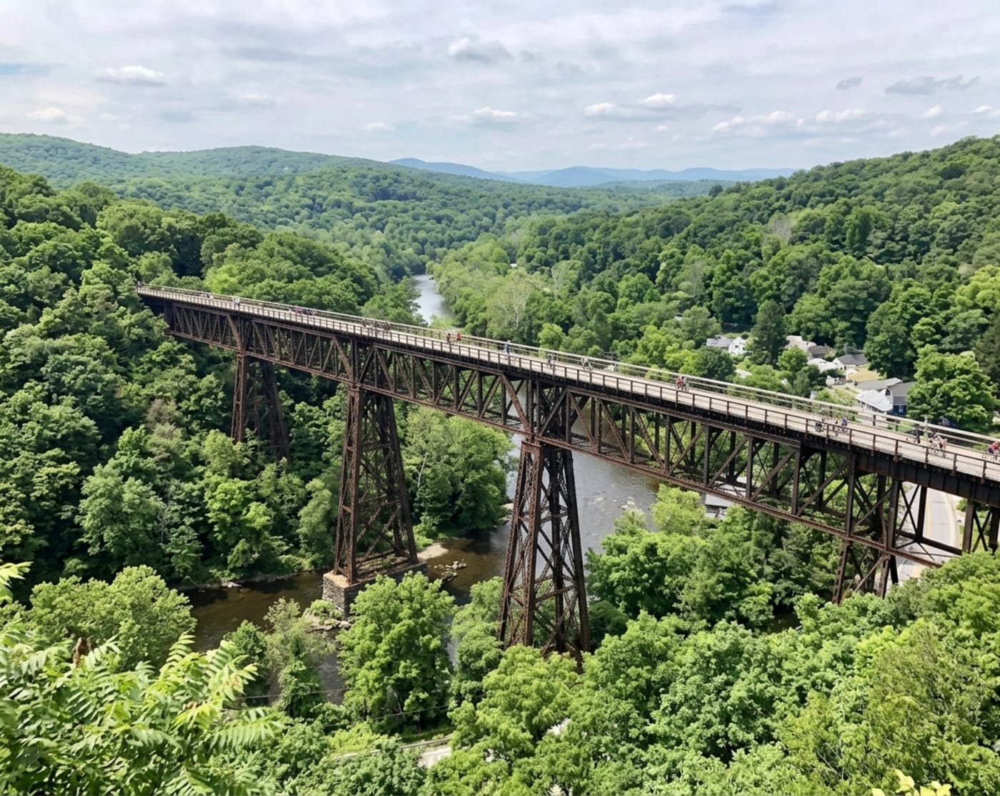
The Iron Guardian of the Rondout: The Wild, Improbable History of the Rosendale Trestle
It was the highest bridge in America when it opened. It was sold for one dollar when it closed. It was nearly converted into a bungee jumping platform. And today it's one of the most spectacular walks in the Hudson Valley.
📅 Rosendale, NY·🌉 Engineering & Trails·⏱ 9 min read
Rosendale Trestle · 940 ft long · 150 ft above Rondout Creek · Wallkill Valley Rail Trail
There is a moment, roughly halfway across the Rosendale Trestle, where you stop walking and just look. To the west, the Shawangunk Ridge runs along the horizon in a long grey-white line. Below you, far below, Route 213 threads through the Rondout Valley like a gray ribbon, and somewhere beneath that, tracing the same path it has followed since 1828, the old Delaware and Hudson Canal bed winds past the limestone cliffs. The wind finds you at this height in a way it doesn't on the ground. The steel under your feet vibrates, faintly, with something, the memory of trains, maybe, or just the bridge being alive in the way that old iron and steel structures are alive, breathing with temperature and weather.
The trestle is 940 feet long and stands 150 feet above Rondout Creek. It took two years to build and was the highest span bridge in the United States when it opened in 1872. It served trains for more than a century. It was sold for one dollar. It was nearly turned into a bungee jumping platform. It sat in decay for decades while locals explored it illegally, drawn to the view and the transgression of being somewhere officially off-limits. And then, in 2013, 141 years after the first train crossed it, it reopened, not to freight or passengers, but to anyone who wants to walk across it, for free, on a summer afternoon.
The trestle's story is Rosendale's story in miniature: industrial ambition, boom, abandonment, and an improbable, community-driven second life.
The Wallkill Valley Railroad and the Problem of Rondout Creek
The Wallkill Valley Railroad was conceived in the 1860s as an economic engine for the agricultural and industrial communities of the Wallkill River Valley. Organized in 1866, it was designed to connect the small towns of Ulster County, Gardiner, New Paltz, Rosendale, to the Erie Railroad at Goshen to the south and to Kingston and the Hudson River freight network to the north. The line reached Gardiner by 1869 and New Paltz in 1870. But completing the route to Kingston meant crossing something formidable: the deep, steep-sided valley of the Rondout Creek.
The Rondout Valley at Rosendale is not a gentle crossing. The creek runs at the bottom of a gorge cut through the same Rondout Formation limestone that had made the town famous for cement. Getting a railroad across it required either a very long detour or a very tall bridge. The railroad chose the bridge. Construction began in 1870. Engineers immediately encountered problems: significant deposits of quicksand beneath the valley floor complicated the excavation for the bridge's piers, delaying the project and adding to costs. The solution required driving piers deep through the unstable ground until they found solid stone, a challenge that gave the final structure nine distinct spans, each supported by its own pier, rather than the simpler two- or three-span design that would have sufficed on firmer ground.
The original structure, completed in 1872, was built in wrought iron using Post-type trusses: a design patented by engineer Simeon S. Post that used a combination of vertical and diagonal members to create a framework that was lightweight relative to its strength. When the first train crossed on April 6, 1872, the trestle was celebrated as a triumph of engineering. It was, at the time of its completion, the highest span bridge in the United States.
Local residents were less certain. Reports of the bridge “swaying” as trains passed made passengers nervous, and the dizzying height, 150 feet is roughly the equivalent of a fifteen-story building, made even experienced travelers grip their seats. The anxiety was not entirely irrational. Wrought iron, while strong in tension, is more brittle than steel and fatigues over time under the repeated stress of heavy loads. As locomotives grew heavier through the late 19th century, the concern became structural rather than psychological.
Trestle by the Numbers
Total length: 940 feet (287 meters)
Maximum height: 150 feet (46 meters) above Rondout Creek
Number of spans: 9
Original material: Wrought iron, Post-type trusses (1872)
Current material: Steel, King Bridge Company reconstruction (1895–1896)
Reopened for pedestrians: June 29, 2013
Restoration cost: $1.5 million
Sale price in 1986: $1.00
Carnegie Steel and “Live” Engineering: The 1895 Reconstruction
By the early 1890s, the railroad had decided the original iron structure needed to be replaced entirely. In 1895, the King Bridge Company of Cleveland, Ohio was contracted to rebuild it in steel. The King Bridge Company was one of the most prominent bridge fabricators in the United States at the time, a Cleveland firm that had built hundreds of bridges across the country and was known for its ability to execute complex projects efficiently.
The reconstruction was an impressive feat of what engineers call “live” work: rather than closing the line and demolishing the old structure first, the new steel bridge was built incrementally around the existing iron one, span by span, so that train traffic could continue with minimal interruption. New steel members, fabricated from Carnegie steel, the dominant American structural steel of the era, were installed around and alongside the old iron trusses. Once each new span was complete and load-tested, the corresponding old iron members were removed. The process was slow, meticulous, and expensive, but it kept the railroad running.
The rebuilt bridge was stronger, stiffer, and better suited to the heavier locomotives of the new century. But its reputation for being “shaky” never entirely disappeared from local memory. Speed restrictions for trains crossing the span were made permanent, a precaution that acknowledged the structure's age and the inherent flexibility of a nine-span bridge at this height.
It's also worth noting a technical distinction that matters to engineers: the Rosendale structure is technically a viaduct, not a trestle. A trestle is typically made of timber with a continuous deck supported by many closely spaced bents. A viaduct is a long bridge with multiple distinct spans supported by separate piers or towers. The Rosendale structure has always been called a trestle in common use, and that name has stuck across 150 years, but purists will note the distinction.
The Wallkill Valley Railroad and the Cement Connection
The trestle was never just a transportation structure. It was infrastructure in the literal sense: it made possible the full industrial output of one of the most productive industrial districts in 19th-century America. The Rosendale cement industry, at its peak, was shipping nearly 10 million barrels of cement per year. That cement needed to get somewhere. Much of it traveled by D&H Canal south to the Hudson River, but the canal was slow and seasonal, freezing in winter and subject to drought in dry summers. The Wallkill Valley Railroad offered a faster, year-round alternative. The trestle was the linchpin that completed the line, connecting the cement-producing heartland of Ulster County to the freight networks of the Hudson Valley.
Stand on the trestle today and look straight down: you are looking at the intersection of three layers of Hudson Valley transportation history at once. Below you runs Route 213. Below that, partially visible in the vegetation, runs the old D&H Canal towpath, now part of the D&H Canal Heritage Corridor. And the trestle itself represents the railroad era that superseded the canal. Three centuries of infrastructure, stacked in the same valley.
Decline, One Dollar, and the Bungee Jumping Era
The mid-twentieth century was not kind to regional railroads. As freight shifted to highways and passenger travel shifted to automobiles, lines like the Wallkill Valley Railroad became economically marginal. The railroad was absorbed into the Penn Central system and eventually into Conrail. Maintenance on the aging trestle became increasingly deferred. By the 1970s, structural deterioration had advanced to the point that trains were required to slow to as little as 5 mph to cross safely, a crawl that made the line commercially unviable.
In 1977, Conrail officially closed the Wallkill Valley rail line. The trestle fell into silence. Tracks were removed beginning in 1983. And then, in 1986, came one of the stranger transactions in the history of American infrastructure: Conrail sold the bridge for one dollar to John E. Rahl, a local businessman, who maintained the purchase granted him the right to restore rail service on the whole Wallkill line.
Rahl had other ideas. Between 1989 and 1991, he installed planking and guardrails on the southern half of the bridge and opened it to the public. His plan was to operate the trestle as a bungee jumping platform: using the 150-foot height over the creek as the draw. Bungee jumping was having a genuine commercial moment in the early 1990s, and the physics were, admittedly, there. The legal situation was not. In January 1992, a court order held that bungee jumping from the trestle violated local zoning laws. The venture was shut down. A second entrepreneur, Douglas Hase, tried again in 2003 and 2004, seeking variances for both bungee jumping and hot air ballooning operations from the trestle. Those attempts also failed.
For the next decade-plus, the trestle existed in a kind of legal limbo: privately owned, structurally deteriorating, officially off-limits, and thoroughly explored by the hikers, photographers, and urban adventurers who ignored the no-trespassing signs and walked out onto the span anyway to see what could be seen from 150 feet above the Rondout Valley. The view, everyone agreed, was worth it.
The Resurrection: $1.5 Million, 110 Donors, and a Rosendale Brass Band
The trestle's path back to legitimacy began in 2009, when Ulster County seized the property in a tax-default sale. The Wallkill Valley Land Trust (WVLT) and the Open Space Institute (OSI) had been developing the Wallkill Valley Rail Trail since 1991, when WVLT purchased the first 12-mile section of former rail corridor between New Paltz and Gardiner. The trail had grown steadily: New Paltz and Gardiner sections opened through the 1990s and 2000s, drawing walkers, cyclists, equestrians, and cross-country skiers year-round. But the trestle, that 940-foot gap over the Rondout Creek, was the missing link that prevented the trail from connecting New Paltz to Kingston in a continuous run.
When the tax-default seizure presented an opportunity, WVLT and OSI moved quickly. They acquired the 65-acre Wallkill Valley Railroad property in the towns of Rosendale and Ulster and immediately began raising money to restore the trestle for pedestrian use. The campaign took four years and raised $1.5 million from an impressive coalition: the New York Office of Parks, Recreation and Historic Preservation; the Samuel Freeman Charitable Trust; the Dyson Foundation; the Rondout-Esopus Land Conservancy; the Friends of the Shawangunks; Mohonk Preserve; and more than 110 individual donors.
The restoration work itself was a community project in the most literal sense. Corten steel railings were fabricated and attached to the steel structure. Damaged railroad ties were replaced. The final step, installing the commercial-grade recycled Trex decking that now forms the walking surface, was completed by volunteers led by WVLT board and staff over six weekends, with snacks and lunch provided by local eateries. A handful of those volunteers still come back monthly to tighten loose screws and address graffiti.
On June 29, 2013, the Rosendale Trestle officially reopened. The Rosendale Brass Band led the first pedestrians across. It was, by any measure, an occasion.
“Standing on the trestle today, one doesn't just see the view; they feel the weight of a century of industrial ambition and the lightness of its modern, recreational rebirth.”, Rosendale Historical Review
The Trestle Today: Empire State Trail and Beyond
The reopening of the trestle effectively doubled the length of the Wallkill Valley Rail Trail, extending it from 12 miles to 22+ miles and connecting it continuously from Gardiner through New Paltz, Rosendale, and Ulster to the Kingston city line. The northern sections of the trail, including the trestle, are now a named segment of the Empire State Trail, the 750-mile walking and cycling route that runs from New York City to Canada and from Albany to Buffalo. The Wallkill Valley Rail Trail is part of a linked regional network that includes the Hudson Valley Rail Trail in Lloyd and the Poughkeepsie-Highland Railroad Bridge (the Walkway Over the Hudson) to the south.
In 2011, OSI and WVLT also acquired 118 acres of Joppenbergh Mountain, a 495-foot ridge that rises directly north of the trestle and is visible from it. The mountain is now preserved open space, adding to the dramatic visual backdrop of the trestle crossing. A 2020–2021 improvement project added stone-dust trail surfacing, rehabilitated three small bridges along the northern stretch, improved road crossings, and added wayfinding signage, a $1 million investment that has made the full trail genuinely accessible to riders and walkers of all abilities.
The trail is open year-round, dawn to dusk, free of charge, for walkers, joggers, cyclists, equestrians, dog walkers, cross-country skiers, and snowshoers. Horses are welcome on the trestle itself, with the request that riders dismount and walk their horses across the span.
Walking It
The closest parking for the trestle is the Binnewater Road lot in Rosendale, about a quarter mile north of the span. From there the trail runs flat and straight, this is a former rail corridor, so there are no hills, south to the trestle and north toward Kingston. The walk across takes about five minutes at a comfortable pace, longer if you stop to look, which you will.
What you'll see looking west: the long profile of the Shawangunk Ridge, the white cliff faces of the Gunks catching morning light. What you'll see looking east: Joppenbergh Mountain, and behind it the low Catskill foothills beginning their climb. What you'll see looking down: the Rondout Creek far below, Route 213 winding through the valley, the old D&H Canal corridor traced in the tree line. On a clear day the full geometry of 19th-century Hudson Valley infrastructure is visible from a single vantage point: canal, highway, railroad, all layered in the same narrow valley, each representing a different era's answer to the same question of how to move goods and people through a landscape.
The Widow Jane Mine and the Century House Historical Society are a short drive east on Route 213, worth pairing with the trestle for a full afternoon in Rosendale's industrial history. The 1850 House Inn & Tavern, just a few minutes' walk from the trail in downtown Rosendale, is a good option if you want to stay the night.
Plan a Visit: Rosendale Trestle
Closest parking: Binnewater Road lot, Rosendale, NY, ~0.25 miles north of the trestle
Trail access: Wallkill Valley Rail Trail, free, open dawn to dusk year-round
Horses welcome: please dismount and walk your horse across the trestle
Surface: Stone dust and recycled Trex decking; suitable for most bikes and strollers
Combine with: Widow Jane Mine / Century House Historical Society (668 Route 213, east of the trestle)
“Celebrating a Milestone Anniversary of the Wallkill Valley Rail Trail: the Opening of the Rosendale Trestle.” Wallkill Valley Land Trust, June 2024. wallkillvalleylt.org
“A Celebration of the Rosendale Trestle.” Wallkill Valley Land Trust, 2020. wallkillvalleylt.org
“Wallkill Valley Rail Trail, New Paltz to South Kingston.” Empire State Trail. empiretrail.ny.gov
“Open Space Institute and Wallkill Valley Land Trust Announce Completion of Wallkill Valley Rail Trail Improvements.” Open Space Institute, December 2020. openspaceinstitute.org
“Rosendale Trestle and Wallkill Valley Rail Trail.” MidAtlantic Daytrips. midatlanticdaytrips.com
The Coal-Fueled Highway: The Rise, Fall, and Astonishing Legacy of the D&H Canal
It was 108 miles long, had 108 locks, cost $6.3 million to build, and was dug entirely by hand in three years. It accidentally created the Rosendale cement industry. And for 70 years, it was the engine that powered New York City's rise.
📅 High Falls / Rosendale, NY·⛵ Industry & Engineering·⏱ 12 min read
D&H Canal · 108 miles · 108 locks · 1828–1898 · National Historic Landmark
There is a number that appears twice in the story of the Delaware & Hudson Canal, and historians never get tired of pointing it out: the canal was exactly 108 miles long, and it had exactly 108 locks. That coincidence, or as one Sullivan County interpretive center puts it, that “oddly by chance” numerical alignment, is the kind of detail that lodges in the memory. Everything else about the D&H Canal is equally specific, and equally startling.
The entire 108-mile waterway was built by hand in three years. It was the first private enterprise project in the United States to cost more than a million dollars to build. It created the Rosendale cement industry by accident. It gave John Roebling his first major engineering commission, decades before he designed the Brooklyn Bridge. It ran a locomotive on American rails for the first time in history. And for 70 years, from 1828 to 1898, it moved the coal that heated New York City, which is to say, it was the energy infrastructure of the country's largest and most powerful industrial city during the critical decades of its rise.
Today, a few fragments of it remain: a stretch of five stone locks in High Falls, a Roebling-designed suspension aqueduct in Minisink Ford, a museum in a Gothic Revival chapel. Most of it has been filled in or swallowed by development. But the valley it traveled, that narrow corridor between the Shawangunk Ridge and the Catskill Mountains, following the Old Mine Road south from Kingston toward the Delaware River, still carries the ghost of the canal in its place names. Port Jervis has a Canal Street. Ellenville and Wawarsing have Towpath Road. Wurtsboro is named for the brothers who built the whole thing.
An Energy Crisis and a Wall Street Demonstration
The D&H Canal began with an energy crisis. The War of 1812 had disrupted the British coal supply that American cities depended on, and New York City, already the country's dominant commercial center, was facing a fuel shortage. The solution, in theory, was anthracite coal from northeastern Pennsylvania: harder, longer-burning, and more efficient than wood or soft coal, with enormous deposits in the Lackawanna Valley mountains around Carbondale.
The problem was getting it to New York. The routes were treacherous, the roads were primitive or nonexistent, and no one had yet proved that anthracite would actually burn reliably in a domestic or industrial hearth. Brothers William and Maurice Wurts, Philadelphia merchants who had purchased land in the coal-rich Moosic Mountains, needed to solve both problems at once.
On January 7, 1825, they solved the second problem publicly and elegantly: they invited New York's business and financial leaders to the Tontine Coffee House on Wall Street to watch anthracite burn. It burned well. The demonstration convinced investors, and a public stock offering in January 1825 raised a million dollars for canal construction. The D&H Canal Company was chartered in 1823 by both New York and Pennsylvania, making it the first major interstate private enterprise in American history.
For the engineering, the Wurts brothers hired the two men who had just finished the Erie Canal: Benjamin Wright, whom ASCE would later designate the Father of American Civil Engineering, and his assistant John B. Jervis, who would go on to build the Croton Aqueduct and numerous other landmark works. Ground was broken on July 13, 1825. After three years of labor by 2,500 men, most of them recent immigrants, working with hand tools in difficult terrain, the canal opened to navigation in October 1828.
D&H Canal By the Numbers
Total length: 108 miles (Honesdale, PA to Rondout Creek, Kingston, NY)
Total locks: 108, overcoming a 972-foot elevation change between Hudson River and Honesdale
Construction cost: ~$6.3 million total (original estimate: $1.2 million)
Peak coal tonnage: ~2 million tons (1870)
Operating years: 1828–1898
The Route: From Carbondale to Kingston
D&H Canal lock at High Falls, NY · One of 108 original locks
The canal's route through the Hudson Valley follows one of the most historically layered corridors in North America. Starting at the Rondout Creek at Creeklocks, between what is now Kingston and Rosendale, the canal ran southwest alongside the Rondout Creek toward Ellenville, then continued through the valley of the Sandburg Creek, the Homowack Kill, the Basha Kill, and the Neversink River to Port Jervis on the Delaware. From there it crossed the river into Pennsylvania on Roebling's Delaware Aqueduct at Lackawaxen and ran northwest along the Lackawaxen River to Honesdale.
The canal didn't go all the way to the coal mines, though. Getting the anthracite from the Wurts' mines in the Moosic Mountains near Carbondale down to the canal at Honesdale required a separate and equally ingenious piece of engineering: the Delaware and Hudson Gravity Railroad, a 16-mile inclined plane and gravity railway that used the natural fall of the mountainside to move loaded coal cars downhill to Honesdale, where they were transferred to canal barges. Stationary steam engines on the uphill planes hauled empty cars back up. No locomotive was needed, gravity did the work.
And then, on August 8, 1829, the D&H made history anyway. To test whether steam locomotion might eventually replace the gravity planes, the canal company imported an English-built locomotive: the Stourbridge Lion. On that date, the Stourbridge Lion became the first steam locomotive to run on commercial railroad track in the United States. The timber trestles were deemed too fragile to support it regularly, and the experiment was shelved, but the milestone stood.
Rosendale · D&H Canal historical photograph · Ulster County, NY
The Rosendale Connection: The Accidental Discovery That Changed Everything
The canal's most consequential unintended consequence happened in its own backyard. During the surveying and construction phase in 1825, engineers hired specifically to look for useful mineral resources along the route turned up something unexpected in the hills near Rosendale: an outcropping of argillaceous dolostone that, when burned and ground, produced a high-quality natural hydraulic cement, a mortar that set and hardened underwater.
The timing could not have been better. The canal needed exactly this material for the hydraulic mortar in its 108 locks and 26 aqueducts. Using a locally discovered cement instead of imported material dramatically reduced construction costs. The D&H Canal Company used it for its own structures and moved on. But the discovery didn't stay local for long.
A local farmer named Jake Snyder recognized what was under his land and went into the cement business. His neighbors followed. Investors arrived. By the 1880s, Rosendale was producing nearly 10 million barrels of cement per year, more than half the entire North American output, and the structures it built included the Brooklyn Bridge, the Statue of Liberty's pedestal, and the U.S. Capitol's west wing. And crucially, a large portion of all that cement left Rosendale by canal barge, shipped down the very waterway that had accidentally discovered it. The relationship was deeply symbiotic: the canal provided the transportation infrastructure that made the cement industry viable at scale, and the cement industry provided a highly profitable secondary cargo that supplemented the canal's coal business and extended its commercial life.
John Roebling, who designed the suspension aqueducts that carried the canal over the Delaware and other rivers in the 1840s, later designed the Brooklyn Bridge, which was built using cement discovered in Rosendale while digging the canal he'd worked on. The connections loop in on themselves with almost novelistic neatness.
Life on the Raging Canal
The boats that worked the canal were not glamorous. Typically 88 feet long and 14 feet wide, designed to fit the lock chambers precisely, they were drawn by teams of two mules walking the towpath alongside the water. The mules were led by a hoggee: usually a boy or girl, often as young as ten, who walked 15 to 20 miles per day alongside the animals, guiding them along the towpath in all weather. Contemporary accounts describe hoggees sleeping on the towpath when exhausted, their mules continuing to walk because the animals had learned the route.
The boats moved slowly, mule-drawn canal boats averaged about 3 to 4 miles per hour, but they moved constantly. At its peak in the 1850s and 1860s, more than 1,400 boats were operating on the D&H, and the canal was running nearly year-round, shutting down only during the winter freeze. Boat families lived aboard their vessels for the season, the cabin at the stern serving as kitchen, sleeping quarters, and living room for an entire family during a months-long working journey.
At each of the 108 locks, the boat had to be slowed and guided into the narrow chamber. Boatmen used thick ropes wrapped around snubbing posts: heavy wooden or stone posts set into the lock walls, to control the barge's momentum. If you walk the Five Locks in High Falls today, you can still see the grooves worn into the stone by decades of rope friction: the physical record of thousands of individual passages, each one a small controlled act of stopping a heavy, moving barge with nothing but a rope and muscle.
The lock tenders who operated the gates and sluices lived in small houses directly adjacent to the locks, available at any hour to raise or lower the water levels. Their job had no off hours during the operating season. Canal-era newspapers, collected by historian Dorothy Sanderson and published as The Raging Canal, document the constant activity, the accidents, the feuds between boatmen, the floods that overwhelmed the banks, the drownings, and the small dramas of a working waterway.
The Five Locks at High Falls: Engineering Precision in Stone
Of all the canal's remaining physical remnants in the Hudson Valley, the most significant are the Five Locks in High Falls, near Rosendale. Locks 16 through 20, they were built as part of the 1847–1850 enlargement of the canal to accommodate increased traffic and larger barges, and they are notable among all 108 locks for the quality of their construction.
Most D&H Canal locks used composite construction: unfitted field stone with a two-inch white oak lining applied to the interior to make the chamber watertight. The High Falls locks are different. They were built of precisely cut and fitted dry-laid Shawangunk conglomerate, the same hard, white quartzite-rich stone that forms the dramatic white cliffs of the Gunks visible from much of the mid-Hudson Valley. No mortar was used; the stones were cut with sufficient precision that they hold together by their own weight and fit. The five locks together raised and lowered barges a total of 63 feet, each with an average lift of about 12 to 13 feet.
The locks were cleared and stabilized in 1999–2000 and are now a National Historic Landmark maintained by the D&H Canal Historical Society. Walking the Five Locks Walk today, you follow the same towpath the hoggees walked, past lock chambers whose stone walls still show the wear of a century and a half of use. A loading quay is visible just past Lock 16. The snubbing post grooves are there if you look for them.
Roebling's Aqueducts and the Suspension Bridge That Survived
Moving a canal across a river is a different engineering challenge than building a bridge: instead of carrying traffic over the river, you need to carry the water itself, a full, heavy channel of it, with canal boats floating inside. The D&H Canal crossed several rivers this way using aqueducts: essentially elevated flumes or troughs that held the canal water while boats passed through them.
John Roebling: the same engineer who would design the Brooklyn Bridge decades later, was hired by the canal company in the 1840s to design four of these aqueducts. His innovation was to apply the wire-cable suspension principle he had been developing to aqueduct design: instead of a rigid masonry or timber structure, he suspended the water-filled trough from wire cables, allowing it to span longer distances with less material. The Delaware Aqueduct at Minisink Ford, completed in 1849, was the largest of the four.
When the canal closed in 1898, the Delaware Aqueduct was converted into a road bridge. It is still in use today as a toll bridge across the Delaware River, the oldest wire suspension bridge in the United States. Three of Roebling's four D&H aqueducts have been demolished; the Delaware Aqueduct alone survives, and it carries traffic more than 175 years after it was built to carry canal boats.
The Canal's End, and Its Long Afterlife
The canal's decline followed a pattern familiar across American infrastructure history: it was replaced by something faster. The New York & Erie Railroad, completed in 1851, provided a parallel route that didn't freeze in winter, could carry more cargo, and moved it in a fraction of the time. The D&H Canal Company recognized the shift and had been investing in railroads since the 1860s. By 1898, only 200 coal-carrying boats were still operating on the canal. That year, the D&H opened all the small overflow dams called waste weirs and drained the waterway. The last boat traversed the canal on November 5, 1898.
The company formally renamed itself the Delaware and Hudson Railroad: a name that acknowledged the transformation that had already happened. The D&H Railroad is still operating today, now owned by Canadian Pacific Kansas City, making the Delaware and Hudson one of North America's oldest continuously operating transportation companies.
The canal itself didn't entirely disappear at once. Catskill rail magnate Samuel Coykendall purchased the canal property after closure and used the northernmost section, from Rondout to Kingston, to continue transporting Rosendale cement and other materials to the Hudson River. That operation continued until 1904. The High Falls section held water until 1901, and the Rosendale section remained in operation until 1917, carrying coal to the cement kilns from the Hudson. The canal outlasted its own official end by nearly two decades, sustained by the same cement industry it had helped create 75 years earlier.
“The D&H Canal was the engine of a young nation, a ribbon of water that brought the warmth of Pennsylvania coal to the hearths of New York and the strength of Rosendale cement to its foundations.”, D&H Canal Historical Society
Walking the Canal Today
The D&H Canal was designated a National Historic Landmark in 1968. Today, its most accessible remnant for Hudson Valley visitors is the Five Locks Walk in High Falls, a short, flat trail that begins adjacent to the D&H Canal Museum on Route 213 and follows the old towpath past Locks 16 through 20. The walk takes about 45 minutes at a relaxed pace; longer if you stop to read the interpretive panels or examine the lock stonework closely.
The D&H Canal Museum itself is housed in a Gothic Revival Episcopal chapel built in 1885, a beautiful and slightly incongruous building for a canal museum, but one that works. The collection includes roughly 4,000 artifacts: maps, photographs, financial documents, a working model of a lock, a life-size recreation of a canal boat cabin, a moving model of a gravity railroad brake car, and original paintings by canal-era artists. The museum store carries an excellent selection of books on the canal and on Hudson Valley history.
High Falls is worth a longer visit. The hamlet sits at the confluence of the canal history, the Rosendale cement history, and the natural landscape of the Rondout Creek gorge. The creek itself drops over a series of waterfalls just south of the village, the same elevation drop that the Five Locks were built to overcome, and the view of the gorge from the bridge on Route 213 is one of the quietly spectacular views of the mid-Hudson Valley.
For those who want to walk further, much of the canal's former route has been incorporated into trail systems. The towpath through the Sullivan County section is preserved as a linear park. The O&W Rail Trail in Orange and Sullivan Counties follows portions of the old corridor. And throughout the valley, if you know the terrain, you can trace the canal's ghost in the landscape: the slight depression of the old bed, the stone walls of aquement structures, the towpath grades that run unnaturally level through country that otherwise rises and falls.
Plan a Visit: D&H Canal History in High Falls
D&H Canal Museum: 23 Mohonk Road, High Falls, NY 12440, canalmuseum.org · (845) 687-9311, open May–October, Sat & Sun 11am–5pm
Five Locks Walk trailhead: Adjacent to 1315 Route 213, High Falls (D&H Canal House)
Five Locks: Locks 16–20, National Historic Landmark, free, accessible year-round
Free guided tours of the Five Locks Walk offered seasonally by D&H Canal Historical Society, check canalmuseum.org for schedule
Roebling's Delaware Aqueduct: Minisink Ford, NY (near Barryville), oldest wire suspension bridge in the U.S., still carries traffic, toll crossing
Nearby: Widow Jane Mine and Century House Historical Society in Rosendale (4 miles east on Route 213)
Built in 1888 as the longest bridge in the world. Abandoned after a fire in 1974. Sold for one dollar. Reborn as the longest elevated pedestrian park on earth. The Walkway Over the Hudson is one of the most unlikely second acts in the Valley's history.
Detroit Photographic Company · Poughkeepsie Railroad Bridge · circa early 1900s
There is a photograph taken sometime around the turn of the last century, a Detroit Publishing Company print, that shows the Poughkeepsie Railroad Bridge from the west bank of the Hudson. The steel cantilever spans cut across the frame at 212 feet above the water, the river below reflecting whatever sky was overhead that day. It looks like exactly what it was: one of the great engineering feats of its era, a structure that changed the economic geography of an entire region.
What the photograph cannot show is everything that happens next. The bridge would carry troops and freight through two world wars. It would fall into neglect, catch fire under suspicious circumstances, sit abandoned for three decades, be sold for a dollar, and eventually be reborn as the longest elevated pedestrian bridge in the world. That is a long story. It starts in 1868 with a newspaper editorial.
The Problem: A River With No Fixed Crossing
For most of the nineteenth century, the Hudson River south of Albany had no fixed crossing. Freight moving between New England and the industrial Midwest had to be loaded onto car floats in New York Harbor and ferried across the water, a slow, expensive, weather-dependent process that rankled railroad operators and shippers alike. The only fixed crossing south of Albany was at Albany itself, which added significant mileage and cost to east-west routes.
In 1868, an article in the Poughkeepsie Journal introduced the idea of building a railroad bridge right here. Poughkeepsie made geographic and economic sense: the bluffs on both sides of the river were high enough to allow bridge construction without blocking river shipping, and the city's rail connections could link the new bridge to lines running in every direction.
Opposition came from Cornelius Vanderbilt's New York Central Railroad, which controlled the Albany crossing and had no interest in competition. A Boston visiting committee was more enthusiastic: “We have no hesitation in saying that it is in the interest of Boston and all of the southern Northeast to have this bridge built as speedily as possible.” It took eighteen more years to actually build it.
The Bridge by the Numbers
1868: First editorial proposing the bridge published in the Poughkeepsie Journal
1871: Poughkeepsie Bridge Company chartered by New York State
1873: First cornerstone laid; the Panic of 1873 stalls construction
1886: Construction resumes under the Manhattan Bridge Building Company
December 29, 1888: Inaugural train crosses
January 1, 1889: Bridge formally opens for service
6,768 feet: Total length of the bridge (1.28 miles)
212 feet: Height above the Hudson River surface
At its peak: 3,500 rail cars crossed daily during World War II
May 8, 1974: Fire ends nearly a century of continuous rail use
1984: Conrail sells the bridge for one dollar
October 3, 2009: Reopens as Walkway Over the Hudson State Historic Park
Building the Impossible
Construction of the Poughkeepsie Railroad Bridge was a genuinely difficult engineering problem. The cantilever design, chosen to minimize falsework over the active river, required precision fabrication and assembly of steel sections that had to bear their own weight as they extended outward before being connected. The structural engineering was led by Charles McDonald and Arthur Paine, associated with the Union Bridge Company of Athens, Pennsylvania, the same firm that had built the Michigan Central Railroad bridge over Niagara River.
Funding came from powerful sources. The Manhattan Bridge Building Company, formed in 1886, had backing from names including Andrew Carnegie and Henry Clay Frick. Construction proceeded in two years, which was remarkably fast for a structure of this scale. The first train crossed on December 29, 1888. For a year, it was the longest bridge in the world.
The bridge was strengthened in 1907 by engineer Ralph Modjeski, who added a third line of trusses down the center and a central girder to handle heavier freight trains. Speed on the bridge was restricted to 12 miles per hour. Modjeski was already familiar with the area; he later designed the Mid-Hudson Bridge, which opened in 1930 just downriver.
Walkway Over the Hudson · 212 feet above the Hudson River · Poughkeepsie to Highland
A Century of Use, Then Decline
At its height, the bridge was a vital freight corridor linking the Pennsylvania coalfields and the industrial Midwest to the factories and ports of New England. During World War II, 3,500 rail cars crossed daily, and the bridge was painted black to reduce its visibility in the event of an aerial attack. The painting continued into the 1960s, though engineers later noted that the absence of paint had actually helped preserve the high-quality Carnegie steel.
The bridge began its long decline when a second Hudson crossing opened at Albany in the 1930s, diverting through traffic that had made the Poughkeepsie route profitable. Railroads began merging and losing money. By the spring of 1974, only one freight train crossed the bridge daily, round trip, and it was, in the words of one account, “poorly patronized.”
Penn Central, which had taken control of the bridge in 1969 and filed for bankruptcy in 1970, halted inspections and cut the maintenance crew. The winter pipeline used to feed fire hydrants on the bridge was not drained, froze, and burst. It was not repaired. The watchmen who had walked the bridge around the clock were eliminated.
“There is 120-year-old Carnegie steel on this bridge. This is one of the great world structures.” — Bill Schaeffer, Walkway Over the Hudson
The Fire of 1974
On May 8, 1974, at 12:42 in the afternoon, the only regular eastbound freight train of the day crossed the bridge. A spark from its brakes presumably ignited the wooden railroad ties and walkways on the Poughkeepsie end of the span. By the time anyone noticed, a cloud of black smoke hung over the river.
Fire Captain Thomas Ringwood later said it “may not have been the biggest fire we've ever had in the city, but it was the most difficult.” Firefighters discovered the burst water pipeline when they tried to use the bridge's built-in fire suppression system. The fire destroyed 700 feet of decking and underlying structure.
Penn Central officials initially said repairs would take four to six months. Those repairs were never made. The bridge sat, unused and increasingly dangerous, for decades. Spikes and chunks of charred wood occasionally fell from it, close enough to Poughkeepsie houses to alarm residents. In 1984, Conrail disposed of the bridge and approximately ten miles of right-of-way for exactly one dollar.
The Long Road Back
What followed was fifteen years of disputes over ownership, liability, and competing visions for the bridge's future. Various proposals ranged from demolition to a toll highway to a shopping mall. In 1991, the Coast Guard recommended demolition as a navigation hazard because no one was maintaining the lights.
The idea of converting it to a pedestrian walkway had existed since the 1890s, when the public had unsuccessfully campaigned for pedestrian access. It reemerged in the 1990s when a small group of citizens, led eventually by Bill Schaeffer, began taking business people, politicians, and anyone who would listen out onto the bridge. They knew that once someone stood on it and saw the views, the argument would make itself.
In 1998, the nonprofit Walkway Over the Hudson organization assumed ownership of the bridge. Fundraising, grant applications, and political organizing consumed the next decade. The Dyson Foundation became a key partner. US Senator Charles Schumer, Congressman Maurice Hinchey, and State Senator Steve Saland lent support. Construction workers were on the bridge even in the middle of winter, in long johns and gloves, tethered to the structure doing metal repair work.
Aerial view · Walkway Over the Hudson State Historic Park · 1.28 miles long
October 3, 2009
The Walkway Over the Hudson State Historic Park opened to the public on October 3, 2009, as a centerpiece of the Hudson-Fulton-Champlain Quadricentennial celebrations. The concrete deck had replaced the old railroad ties. The railings had been refurbished. A 21-story glass elevator now connects the Poughkeepsie waterfront at Upper Landing Park to the bridge deck.
At 6,768 feet long and 212 feet above the river, it is the longest elevated pedestrian bridge in the world. It connects the Hudson Valley Rail Trail on the Highland side to the William R. Steinhaus Dutchess Rail Trail on the Poughkeepsie side, forming part of the Empire State Trail. It was inducted into the Rail-Trail Hall of Fame in 2016. In 2009, it was designated a National Historic Civil Engineering Landmark by the American Society of Civil Engineers.
The views are exactly what Schaeffer knew they would be: north to the Catskills, south to the Hudson Highlands, and straight down 212 feet to the river that the bridge has been crossing for over a hundred years.
Our First Retail Partner: This Little Light of Mine, Gardiner, NY
The whole thing started with a conversation in New Paltz. By the time the design was done, it belonged to Gardiner.
📅 Gardiner, NY·📍 Local Business·⏱ 5 min read
🪂Gardiner, Ulster County, NY · Drop Zone Capital of the Hudson Valley
When I first started building That Dawg Design Co. and sharing that with my local retailer friends in New Paltz, they expressed a need for a nicer design that represents the local area and can cater to the tourists and local pride. That is how I started designing That Dawg Local designs.
When I made my first Gardiner design, Ingrid at This Little Light of Mine Candle Shop asked me to add the parachuters, which absolutely made sense and truly made the design.
Why the Parachuters
Gardiner is known for Skydive the Ranch, established in 1983. I personally used to spend a lot of time with some of the instructors there in my late teens, so I am very familiar with what that place means to the town. It felt like the iconic scene of Gardiner, and with the silhouette of the Shawangunk ridgeline below, it was perfection. Two parachuters descending together over those fields, that view is something you recognize immediately if you know Gardiner.
The Partnership
This Little Light of Mine officially moved their shop from New Paltz to Gardiner in the spring of 2026 and became the perfect partnership for That Dawg Local. We are so proud to partner with someone who makes her goods completely by hand and is a true lover of dogs. Her handmade candles will also be joining the That Dawg Local product lineup soon, so stay tuned.
How the District Model Works
The exclusivity is district-based, not town-wide. A shop in New Paltz could carry the Gardiner parachuter shirt if they wanted to. What they cannot do is carry the New Paltz design if that district is already claimed. No one else in This Little Light of Mine's shopping district gets to carry the Gardiner design as long as she holds that spot. It protects the retailer in their own backyard without locking the designs out of the rest of the valley.
Retailer Spotlight
Store: This Little Light of Mine
Address: 2260 Route 44/55, Gardiner, NY 12525
What they make: Handmade candles and curated goods
District: Gardiner, Ulster County (exclusive)
Design: The Parachuters, No. 1
Territory status: Closed
What's Next
Gardiner is closed. The line keeps moving: New Paltz, Rosendale, Highland, Poughkeepsie, Newburgh. Each town gets its own design, its own story, its own retailer. If you have a shop in one of those towns and you want to talk about being first in your district, reach out before someone else does.
Every fall, thousands show up for the cider donuts and the Instagram moments. Most have no idea they're standing in one of the most strategically perfect apple-growing regions ever assembled by nature and human ingenuity together.
📅 Highland, NY·🏘️ Town Spotlight·⏱ 7 min read
🍎Highland, Ulster County, NY · Apple Capital of the Hudson Valley
Highland, Ulster County, NY · Apple Capital of the Hudson Valley
Here's the part most people miss when they're pulling on their flannels and loading the car for apple season: this didn't happen by accident. The Hudson Valley didn't just become apple country. It was engineered into it, a quiet, centuries-long interplay of geography, climate, infrastructure, and human stubbornness that created something almost unfairly perfect for growing apples.
Highland sits at the center of it. And it's worth understanding why.
The River That Acts Like a Thermostat
The Hudson River is tidal well past Highland, and that massive body of water functions as a natural climate regulator. It absorbs heat slowly through warmer months and releases it gradually as temperatures drop. For apple trees, this is everything:
Warmer falls mean a longer growing season, allowing fruit to fully mature and develop complex flavor
Cooler springs delay the bloom period, protecting blossoms from late frosts, the single biggest threat to any orchard's yield
The result is a remarkably consistent microclimate, year after year, that most apple-growing regions can only dream about
“Our region was doing an international trade in fruit, shipping to England, the West Indies, and it built wealth.”
Soil and Slope: A Glacial Inheritance
The land around Highland carries a geological inheritance from the last ice age. As glaciers retreated, they left behind well-drained, mineral-rich soil with just enough slope to allow water and cold air to drain away from tree roots. That slight elevation above the river plain is, in fact, a critical frost defense. Cold air is denser than warm air and flows downhill. Orchards positioned on higher ground let that cold air drain away, keeping blossoms safe from the frost pockets that devastate lower-lying farms.
It wasn't designed. It was discovered. And once farmers figured it out, they never left.
Deep Roots: How Apples Came to the Valley
Apples are not native to North America. Only crab apples are. But European settlers recognized immediately what the land here could do. Governor Peter Stuyvesant planted an apple tree from Holland in 1647 in what is now New York City, and there is evidence that “Indian Orchards” existed in Ulster County as early as 1671. The Dutch brought apples into the valley, and the English planted them on Long Island. Within a generation, fruit had spread across the region.
By 1875, the New York State census counted over 18 million apple trees statewide. The labor force that tended them expanded too, drawing Irish immigrants who'd fled the potato famine, Italian workers who came for the D&H Canal and Catskill Aqueduct, and during World War I, women recruited from New York City through a program inspired by Britain's Women's Land Army.
Highland by the Numbers
1790: The Farmers' Turnpike in Highland (now the Milton Turnpike) commissioned specifically to move fruit to docks for NYC shipping
1820s: First commercial orchard in eastern NY established in nearby Esopus for fresh-fruit export
22% of New York's commercial apple acreage is in the Hudson Valley
600+ commercial orchards across New York State
30 million bushels in a good harvest year statewide
1976: Apple designated New York's official state fruit
The Bridge That Changed Everything
For centuries, the orchards of Highland produced abundantly, but distribution was limited. Fruit traveled by sloop and then steamboat down the Hudson to New York City markets. The geography kept the industry local.
Then, in 1888, the Poughkeepsie Railroad Bridge was completed, today known as the Walkway Over the Hudson. One of the first designated public roads in the mid-Hudson, the Farmers' Turnpike in Highland, was commissioned in 1790 for use by farmers to transport fruit and cider to the docks in Milton for shipment to New York City. The railroad bridge went further. Suddenly, apples could move east to New England markets, reducing spoilage, increasing reach, and transforming Highland from a strong local producer into a regional distribution hub almost overnight.
The bridge wasn't built for apples. But apples were one of the things it changed most.
The Farms That Are Still Here
What makes Highland distinct from most apple regions is that the farms didn't consolidate or industrialize. They stayed family-owned, generation after generation, each one adapting but never abandoning the land.
Wilklow Orchards has been farmed by the same family for six generations. They run CSAs in spring, live music in summer, pick-your-own in fall, and sell at farmers markets throughout the year, all while trying to be sustainable and ecologically minded because they want the farm to last another six generations.
DuBois Farms is a different kind of story. Twenty-three years ago, Dave and Jolee DuBois purchased a 54-acre farm that was destined to be sold entirely for development. By replanting orchards and vineyards and revitalizing neglected fruit trees, they created what is now a full agritourism destination with a winery, brewery, bakery, and pick-your-own operation that draws visitors from across the Northeast.
Prospect Hill Orchards in nearby Milton has been continuously farmed by the Clarke family since the farm's founding, starting as a self-sustaining homestead and gradually shifting to tree fruits as the regional market for fresh produce grew.
6
Generations at Wilklow
54
Acres saved by DuBois
30+
Apple varieties grown locally
1888
Year the bridge opened markets
More Than Apple Picking
The evolution of these orchards into agritourism destinations is real and significant, but it rests on a foundation that is easy to miss when you're distracted by a hayride. What you're walking through when you visit a Highland orchard is the result of centuries of microclimate observation, geological luck, infrastructure investment, and family persistence.
The cider donut is great. The apple is better when you know where it came from.
When you hold one in your hand, you're holding a river that acts like a thermostat, soil left by glaciers, a bridge that opened up markets in 1888, and at least six generations of someone's family who decided this land was worth staying on.
That's what Highland is. It's just not what it says on the sign.
References
“How the Hudson Valley Became a Land of Orchards.” Hudson Valley One, Oct. 2023. hudsonvalleyone.com
“History of Fruit Growing in the Hudson Valley.” Cornell University Jentsch Lab. blogs.cornell.edu